
| Kona | Air Tour | Saddle | Kilauea | Kamokuna | Hilina | Napau | Waipio | Glossary (Volcanoes) | Glossary (Geology) | Bottom |
Last updated January 21, 2006
A January, 1999 medical imaging meeting on the the Big Island of Hawaii afforded this amateur geologist a long-awaited opportunity to explore one of the most primeval geologic settings on the planet—the world's most active volcanoes, Kilauea and Mauna Loa, on the world's most isolated landmass atop Earth's most vigorous hot spot. A return visit in June, 2000 provided additional material.
This hypertext photo journal is organized loosely by itinerary and photographic sequence. My original intent in creating it was to record my experiences in Hawaii, to organize my photos, and to consolidate my understanding of both for my own future reference. In this last regard, the effort has been particularly worthwhilegetting back up to speed for the June, 2000 return was a snap.
I've posted this site in gratitude to all those who took the time to post their knowledge of Hawaiian geology for my edification.
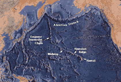
Simply to emphasize the planetary scale of the forces at work here. The Hawaiiain islands currently above water may seem unimpressive on a world map, even with the water taken away, but the raw dimensions of the entire Hawaii-Emperor seafloor process—6,000 km long and 1,000 km wide at the surface, 750,000 km3 of basalt delivered over at least 70 million years—reveal the immense scale of the Hawaiian phenomenon in both space and time.
For those unfamiliar with geologic terminology, my apologies for using the jargon without first defining the terms. Had I done differently, there'd be a lot more text. To make up for the inconvenience, every page on this site has links to UCSD's specific ^volcanologic glossary and Steven M. Richardson's excellent general ^Illustrated Glossary of Geologic Terms. Another excellent resource is the ^US Geological Survey Photo Glossary of Volcano Terms.
Many of the links here lead to other sites offering an in-depth look at the topic at hand. Such external links are prefixed with a carat "^". Your browser's back button should get you back to the jumping-off point when you're ready to return to this site.
 The Hawaiian hot spot is a narrow, zoned region of partial melting pancaked against
the underside of the central portion of the Pacific Plate 60 km below the ocean
surface. The hot spot generates
the basaltic magmas that penetrate and pile up on the
ocean floor in large volume to form the massive ocean island volcanoes of the
Hawaii-Emperor seamount chain (right). The hot spot currently moves through the Pacific
Plate at ~9 cm/yearover 10 times faster than your fingernails grow and a very brisk pace as
plate processes go.
The Hawaiian hot spot is a narrow, zoned region of partial melting pancaked against
the underside of the central portion of the Pacific Plate 60 km below the ocean
surface. The hot spot generates
the basaltic magmas that penetrate and pile up on the
ocean floor in large volume to form the massive ocean island volcanoes of the
Hawaii-Emperor seamount chain (right). The hot spot currently moves through the Pacific
Plate at ~9 cm/yearover 10 times faster than your fingernails grow and a very brisk pace as
plate processes go.
The origin of the Hawaiian hot spot remains controversial. Several leading geophysicists (Don Anderson and Warren Hamilton among them) now prefer to think of it as a migrating decompression melt focused at the head of an immense tension crack propagating first to the south and then to the southeast through the Pacific Plate. The location of the crack is controlled by the structure of the Pacific Plate itself. The southerly trend of the Emperor seamount chain took the crack between the strong, thickened Late Jurassic-Early Cretaceous crust of the Hess and Shatsky Rises (not shown). The 60° dogleg at the north end of the Hawaiian Ridge allowed the crack to skirt the similarly strong, thickened oceanic crust of the Mid-Pacific Mountains. It also happens to coincide with the Waghaener-Mendocino Fracture Zone, which separates oceanic lithosphere differing in age by 10-15 Ma with markedly different mechanical properties. All these ocean floor structures predated the passage of the hot spot.
As the earth's largest plate, the Pacific is no doubt subject to a very complicated pattern of stressesmostly compressional, but with many recognizable extensional features as well. This camp would explain many of the Pacific's linear seamount chains the same way, and they have a large and growing body of compelling geophysical data on their side.
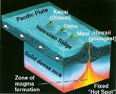 IMO, the propagating tension crack model of the Hawaiian hot spot will
ultimately win out, but many geoscientists still attribute it to a narrow
and relatively fixed plume
of heat originating 2,900 km down at the mantle-core boundary, as illustrated at
right. According to the popular plume model, at least 70 million years (my) of
Pacific Plate motion over the fixed plume beneath the hot spot left a 6,000
km-long angled trace recording the Pacific Plate's motion. The bend between the old eroded
south-trending Emperor seamounts and the younger southeast-trending
Hawaiian Ridge marks an abrupt change in Pacific Plate motion
relative to both the hot spot and the North American plate around 45±2 my ago.
Plume advocates have speculated that the Pacific plate might have changed
direction in response to a global plate motion reorganization occasioned by the
onset of continent-continent collision at the Indian-Eurasian plate boundary at
around the time of the bend, but seafloor magnetic patterns and mid-ocean ridge
geometries throughout the Pacific basin record an unwavering Pacific Plate
trajectory since well before 45 Ma.
IMO, the propagating tension crack model of the Hawaiian hot spot will
ultimately win out, but many geoscientists still attribute it to a narrow
and relatively fixed plume
of heat originating 2,900 km down at the mantle-core boundary, as illustrated at
right. According to the popular plume model, at least 70 million years (my) of
Pacific Plate motion over the fixed plume beneath the hot spot left a 6,000
km-long angled trace recording the Pacific Plate's motion. The bend between the old eroded
south-trending Emperor seamounts and the younger southeast-trending
Hawaiian Ridge marks an abrupt change in Pacific Plate motion
relative to both the hot spot and the North American plate around 45±2 my ago.
Plume advocates have speculated that the Pacific plate might have changed
direction in response to a global plate motion reorganization occasioned by the
onset of continent-continent collision at the Indian-Eurasian plate boundary at
around the time of the bend, but seafloor magnetic patterns and mid-ocean ridge
geometries throughout the Pacific basin record an unwavering Pacific Plate
trajectory since well before 45 Ma.
![Mauna Loa towering above Kilauea caldera in morning light looking north from Volcano House. [C-2020Z]](kilauea/kil17.jpg) Its
origin notwithstanding, the Hawaiian hot spot currently sits under the southern end of the
Big Island. The immense million-year-old volcanic pile
accumulated there thus far culminates in ^Mauna Loa
(right), the planet's largest mountain and largest active volcano. No
camera can do justice to the hulking majesty of Mauna Loa's broad
subaerial shield, which rises 4,170 m (13,679 ft) above sea level.
Towering an astounding 17 km (almost 56,000 ft) above a deeply
sagging base on the ocean floor nearly 150 km (90 miles) wide,
Mauna Loa's total volume is estimated at 80,000 km3.
That's over 800 times larger than California's 4,317 m (14,161 ft)
Mt. Shasta (~100 km3) and many times larger than
Everest. The Big Island's total volume exceeds 100,000 km3.
Its
origin notwithstanding, the Hawaiian hot spot currently sits under the southern end of the
Big Island. The immense million-year-old volcanic pile
accumulated there thus far culminates in ^Mauna Loa
(right), the planet's largest mountain and largest active volcano. No
camera can do justice to the hulking majesty of Mauna Loa's broad
subaerial shield, which rises 4,170 m (13,679 ft) above sea level.
Towering an astounding 17 km (almost 56,000 ft) above a deeply
sagging base on the ocean floor nearly 150 km (90 miles) wide,
Mauna Loa's total volume is estimated at 80,000 km3.
That's over 800 times larger than California's 4,317 m (14,161 ft)
Mt. Shasta (~100 km3) and many times larger than
Everest. The Big Island's total volume exceeds 100,000 km3.
 Still active but apparently past
its main shield-building stage, Mauna Loa last erupted in 1984,
when flows from its Northeast Rift Zone threatened Hilo. For over
a century, however, the most spectacular locus of Hawaiian
volcanism has been ^Kilauea, a younger, smaller shield volcano built
on Mauna Loa's south flank. Kilauea and Mauna Loa together host
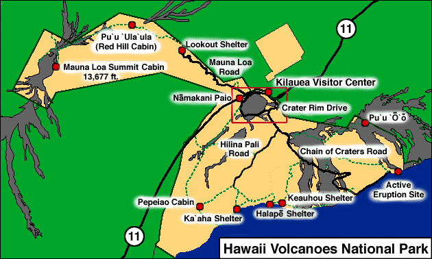
the not-to-be-missed ^Hawaii Volcanoes National Park
(HVNP) centered around the Kilauea
Caldera, a 4-mile-wide
summit collapse containing Halemaumau
Crater, until recently the
primary site of activity at Kilauea.
Still active but apparently past
its main shield-building stage, Mauna Loa last erupted in 1984,
when flows from its Northeast Rift Zone threatened Hilo. For over
a century, however, the most spectacular locus of Hawaiian
volcanism has been ^Kilauea, a younger, smaller shield volcano built
on Mauna Loa's south flank. Kilauea and Mauna Loa together host
the not-to-be-missed ^Hawaii Volcanoes National Park
(HVNP) centered around the Kilauea
Caldera, a 4-mile-wide
summit collapse containing Halemaumau
Crater, until recently the
primary site of activity at Kilauea.
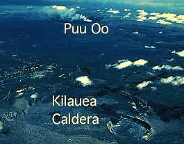
 While Kilauea Caldera and Halemaumau have
been quiet since 1982, the longest-running of historic Hawaiian
eruptions has issued continuously from 1983 to the present from
the Pu'u O'o vent on Kilauea's highly active East Rift Zone (ERZ).
Meanwhile, the submerged ^Loihi Seamount, Hawaii's newest volcano, continues to rise low on
Kilauea's south flank. Click ^here
to see a diagram showing how Mauna Loa, Kilauea and Loihi
currently share the Hawaiian hot spot.
While Kilauea Caldera and Halemaumau have
been quiet since 1982, the longest-running of historic Hawaiian
eruptions has issued continuously from 1983 to the present from
the Pu'u O'o vent on Kilauea's highly active East Rift Zone (ERZ).
Meanwhile, the submerged ^Loihi Seamount, Hawaii's newest volcano, continues to rise low on
Kilauea's south flank. Click ^here
to see a diagram showing how Mauna Loa, Kilauea and Loihi
currently share the Hawaiian hot spot.
Under the weight of the Hawaiian Ridge, the heat-weakened Pacific plate sags downward to form the Hawaiian Deep, a trough reaching 0.5 km (1,500 ft) below average ocean depth around the youngest Hawaiian islands. The Hawaiian Deep in turn runs along the crest of the Hawaiian Arch, a much broader welt nearly 1,000 km across raised by the excess heat and mantle material drawn to the underside of the Pacific Plate by the Hawaiian hot spot. Giant submarine landslides resulting from catastrophic failures of the unstable flanks of Hawaiian volcanoes have been known to overtop the Hawaiian arch to deposit sediments as far as 1,000 km from the source islands. Huge tsunamis from such slides have washed fresh reef fragments onto Hawaiian mountainsides 1,000 ft above sea level.
Big Island indeed. Now think of dozens of Big Islands rising up and eroding away along the hot spot track over 70 my or so and you have an idea of just how prolific the Hawaiian hot spot has been. Of the more than 100 hot spots active on Earth in the last 10 my, few approach the output of Hawaii's.
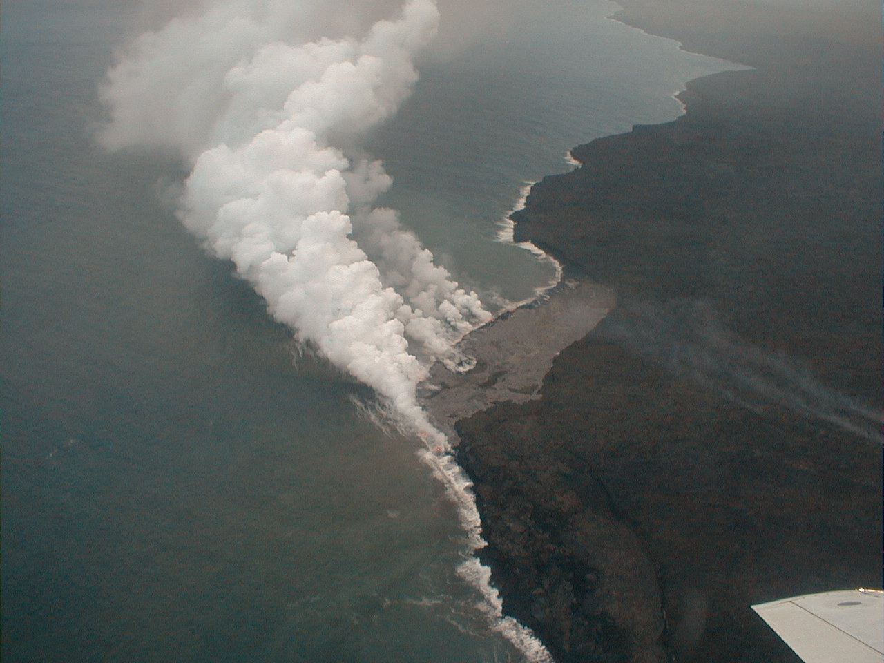 Photo Tour
This geologic photo tour of the Big Island features
All the January, 1999 photos are original JPEGs taken with an Olympus D-340L digital camera in the hands of a rank amateur, with or without Tiffen 2.0x telephoto and 0.5x wide angle lens adapters. (The circular vignetting marks the telephotos.) The smaller images are 640x480; the larger are 1280x960 in size. Unless otherwise indicated, all photos are from January, 1999.
All the June, 2000 photos are original JPEGs taken with an Olympus C-2000Z digital camera using various filters and conversion lenses and HQ recording. The smaller images are again 640x480; the larger are generally also 1280x960 but may range up to 1600x1200 in size. All June, 2000 images are annotated as such in the text accompanying them.
 Hawaiian Geology
Links
Hawaiian Geology
LinksBelow are just a few of the many, many interesting and worthwhile websites relating to Hawaiian geology:
In addition to the Internet sources above, the following print sources figured prominently in my research for this trip and site:
| Kona | Air Tour | Saddle | Kilauea | Kamokuna | Hilina | Napau | Waipio | Glossary (Volcanoes) | Glossary (Geology) | Top |
Please address comments and corrections to jeremy@cliffshade.com
© Jeremy McCreary; last updated January 21, 2006