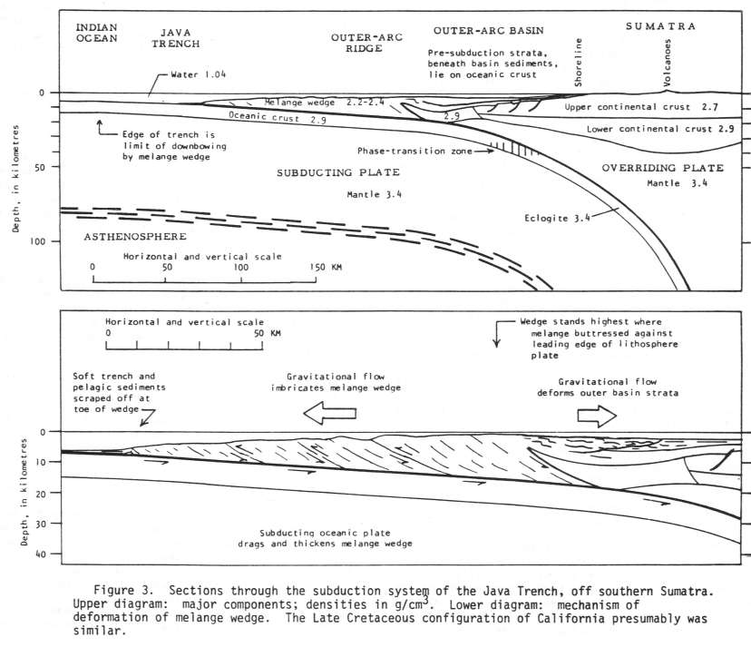
|
| |
Groundwork
The Earth At Work
Planetary Structure and Dynamics Pertinent To Colorado's Physical
Evolution
|
 |
Last modified 01/16/05
 Under
construction Under
construction
Top
Page Index
Context
 |
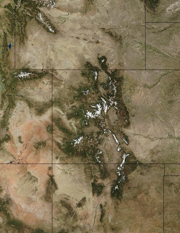
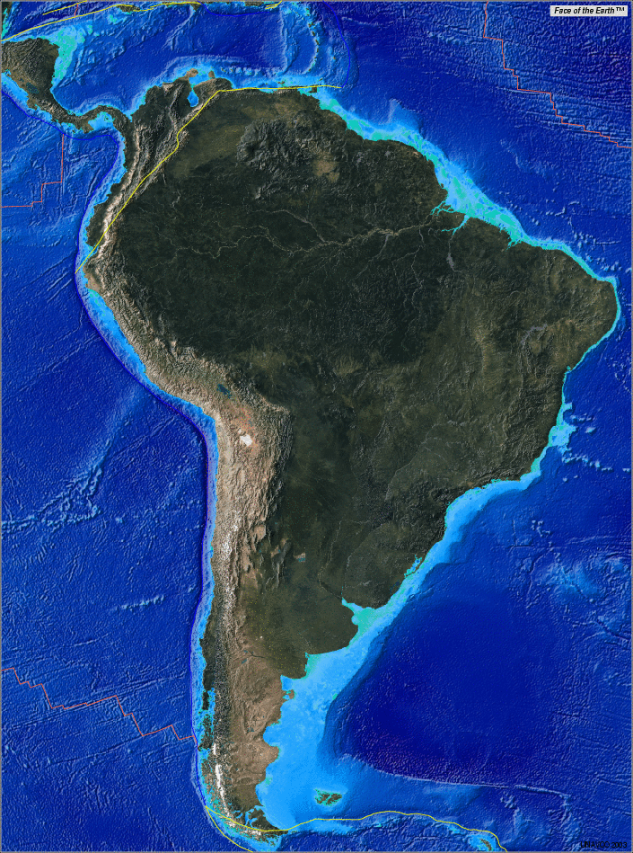
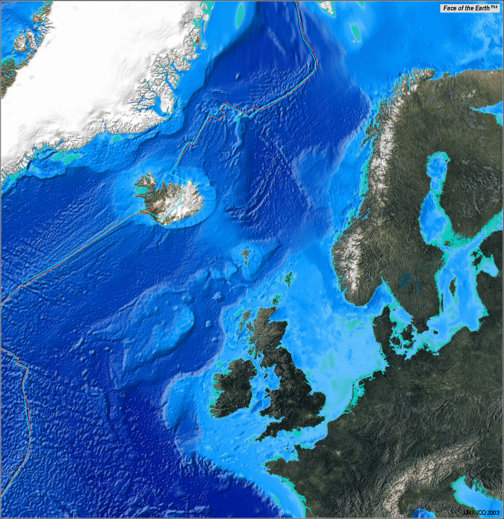
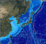
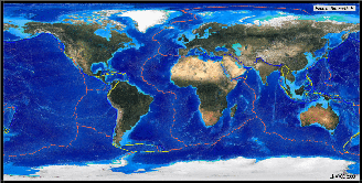
Colorado in context
|
A good understanding of Colorado's physical history and rocks
requires a feel for large-scale geodynamics. This groundwork article
attempts to provide just that context while supporting the photojournals
and other groundwork articles that draw on such ideas.
Most importantly, this article seeks to provide a basis for appreciating if
not answering the $64,000 geo-question about Colorado:
How do you get a long-enduring and still rising world-class mountain
range in a deep intraplate setting subject for the
last 1.4 Ga to at most the far-field effects of first-order
plate interations?
As of 2004, no one even pretends to know the answer, but it sure is fun to
think about. To many trained minds, anomalous upper
mantle stirrings and enduring lithospheric
weaknesses must enter the Colorado equation, but how and why remain as big a pair of
mysteries as you'll find in geoscience.
Speaking of mysteries, you may wonder why marine processes receive so much attention
in this article when the
nearest true ocean is over 1,000 km away and has been for at least 1.4 Ga. There are two good reasons. First, much of
Colorado's landscape came from the sea, however continental it may seem today.
Its basement was largely cobbled together from a host of
island arcs and backarc basins
between 1.78 and 1.65 Ga, and marine deposits as young as ~70 Ma make up a good bit of its
sedimentary cover. Together, these marine contributions account for much of the
rock exposed in Colorado today. Second, subduction of
ocean floor has driven the planet's surface dynamics since at least the onset of plate tectonics at ~2.0
Ga. Details of the subduction process and of ocean floor creation and anatomy
become pertinent at many points in Colorado's story.
Top
Page Index
The Theory of Plate Tectonics
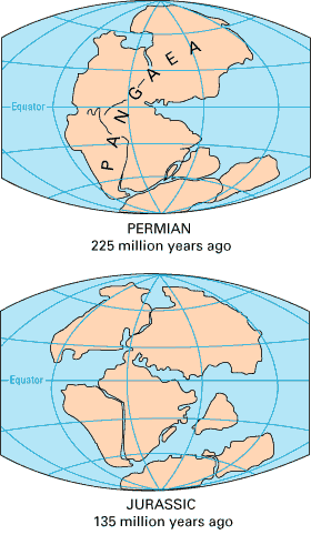 |
Pangea, complete and during break-up
|
Since
its emergence in the early 1960s, the theory of plate tectonics has evolved
rapidly. Today, it's a theory only in the sense that relativity and
quantum mechanics are theories: The testable predictions having been thoroughly
confirmed, no one seriously doubts the basic premises at this juncture, but
significant challenges and shortfalls remain here and there. As a site of
substantial and long-lived intraplate deformation, Colorado embodies
more than its share of the remaining difficulties in plate tectonics, but the
state's early evolution can only be understood within that framework.
Version 1.0
Through
the pioneering work of a small group of geophysicists and physical
oceanographers, the fundamentals of the theory of plate tectonics
fell quickly into place in the 1960s. Once the fundamentals and their immediate
implications were taken seriously, many important details of the theory quickly took
shape. Among the founders were Harry Hess, Robert Dietz, J. Tuzo Wilson, Ron
Mason, Fred Levine, Drummond Matthews, Lawrence Morley, Walter Pitman, Bill
Menard, Bruce Bolt, Jack Oliver, Xavier Le Pinchon and Dan
McKenzie, many of whom worked under essential facilitators like Maurice Ewing of
Columbia's Lamont-Doherty Geological Observatory and Teddy Bullard of Cambridge.
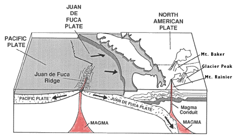 |
Spreading center and subduction zone, USGS
|
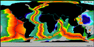
To a large extent, the early work in plate tectonics was provoked by
startling new geophysical observations coming out of
-
the U.S. Navy's newfound Cold War interest in
the oceans, where the topographic and magnetic effects of plate interactions
happen to be the clearest, and where some 80% of the planet's plate
boundaries happen to reside, and
-
the first-ever world-wide seismographic network,
sponsored by the U.S. Defense Department to monitor nuclear weapons tests
but also quite capable of listening in on plate interactions and yielding
important information on the structure and behavior of the plates
and the mantle at depth.
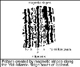 |
Magnetic stripes
|
Once people started looking at the ocean floor in earnest, arresting patterns of topography, magnetism (right) and
global seismicity quickly emerged. Never before seen or even imagined, these new
data sets demanded explanations that theories of the earth based on fixed
continents simply could not provide.
The earliest plate tectonic notions were easily summed up in grossly
oversimplified cross-sectional
cartoons showing plates spreading apart, subducting,
colliding, and sliding past each other at homogeneous plate
boundaries. The only possible driving force for plate
motions anyone could think of at the time was simple pot-on-the-stove Rayleigh-Bénard convection
within a homogeneous single-layer mantle.
Version 2.0
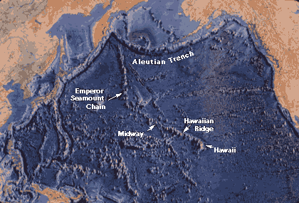 |
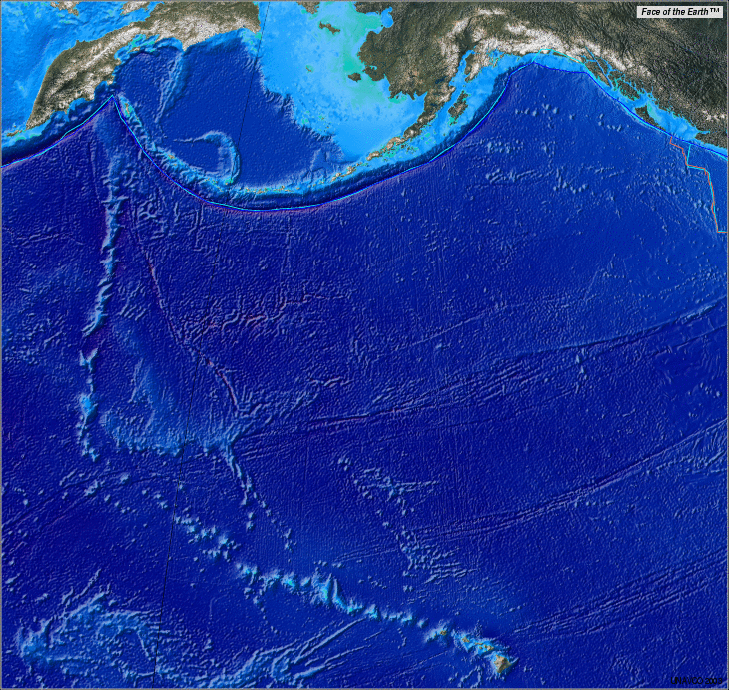
Northern Pacific floor with Hawaii-Emperor and many other volcanic chains
|
Plate tectonics version 2.0 developed in the 1970s and 1980s
with the recognition that
-
real plate boundaries
vary considerably along strike (i.e., from point to point along their
lengths)
-
mixed plate boundary types are common
-
plates aren't all that rigid after all
-
plate interactions should also explain, or at
least jibe with, large continental features like mountain belts and long
faults
-
intraplate deformations
like the Rocky Mountains and Basin and Range
provinces of the western United States and major midplate volcanic disturbances like
the ^Hawaiian Islands had to
fit in somehow
The simple 2D cross-sections of the early days were no
longer adequate, and the role of the mantle had become at
once more complex and less clear. Among the version 2.0 pioneers making lasting
contributions were Tanya Atwater, Peter Molnar, Warren Hamilton and Bill Dickinson.
As attention turned to the continents and hot spots
(excessive volcanic disturbances like Hawaii), the theory stretched to
incorporate mantle processes not directly tied to plate
motions. In 1971, W. J. Morgan introduced the idea of a narrow plume
of heat rooted in the lower mantle to explain the long angled
trace of
the Hawaii-Emperor chain (above). Plumes were soon invoked to explain all kinds
of hot spots, including midplate magmatism at
Yellowstone, isolated ocean islands like the Galapagos,
oceanic basaltic plateaus like Iceland and triple
junctions like Afar. Suddenly plumes were everywhere,
often in places that could be explained much more simply without them.
Note that version 1.0 and 2.0 ideas continue to dominate both professional
and popular geologic accounts—particularly those in the displays and books
offered at tourist attractions of geologic interest.
Version 3.0
|
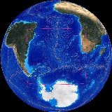
Colorado in context
|
By
the late 1990s, geoscience found itself struggling to move beyond earlier
formulations of plate tectonics, just as the founders of plate
tectonics had struggled against the fixed-continent establishment of their
day. Among the pioneers of plate tectonics version 3.0 are geophysicists Don
Anderson and Warren Hamilton. This revision is still in progress.
It's been slow to die, but Morgan's plume model continues to
lose
credibility as ever more reliable and far-reaching geophysical observations
tighten constraints on the workings of the plates and
the mantle at depth. As the structure of the mantle and
the importance of extensional stresses in locating hot
spots became clearer, lower mantle convection, if
it occurs at all, had
to be decoupled from surface processes, and upper mantle convection had to be
seen as a result far more often than a cause of plate interactions.
In plate tectonics, version 3.0, the lithosphere is viewed as a far-from-equilibrium open thermodynamic
system of self-organizing semi-rigid plates acting to
dissipate crust and mantle heat. The plates are weak in
extension and permeable to
melt from the underlying, barely solid asthenosphere. Top-down
cooling and gravity are now seen as the exclusive driving forces behind plate
motions. The largely passive upper mantle receives heat from the lower mantle
only by
conduction and cools primarily through seafloor spreading
(60%) and subduction. Subduction-related hinge
rollback and overriding plate extension have
emerged as the fundamental shapers of the face of the earth. Hot
spots are now seen as excessive volcanism focused by extensional plate
failures or, in rare cases, by local and relatively shallow thermal disturbances related to upper mantle temperature
variations induced by nearby plate motions.
This article presents the planetary structure and dynamics underpinning
Colorado's physical evolution from a plate tectonics version 3.0
perspective. In this endeavor, I owe a great debt to Warren Hamilton, whose
gift of an informal but incisive personal education in v.3 tectonics I'll always
cherish.
The only thing better than a home planet full of beauty, power and fascination
is one that's finally starting to make some sense.
Top
Page Index
You Can't Tell the Plates Without a Program
|
Colorado in context
|
Since its
initial Early Proterozoic
assembly via subduction-related collisions at 1.78-1.65
Ga, Colorado has been far removed from active
plate boundaries, but far-field effects from distant plate interactions to the west, south and east
continued to play important roles in its evolution well into Tertiary time, both at the surface and at depth. Before launching into the
planetary dynamics needed to put Colorado's physical evolution
into a current plate tectonic framework, we'll need to spend
some time getting to know the playing field and the
players.
Deep Time and Jargon
Having a hard time remembering the Cretaceous? To brush up on geologic time scales and nomenclature,
try this deep
time refresher. You might also want to keep a browser window open on the ^University of California (Berkeley) Museum of Paleontology
Web Geological Time Machine. You'll find links
to additional geologic timelines and glossaries on the search
page.
Before Plate Tectonics
The current planetary structure described below had quite literally fallen into place by ~4.4 Ga, but
plate tectonics has operated on planet Earth only in the
last ~2.0 Ga (from 13:20 hours on). Prior to
that, a much hotter earth lacked the crustal and upper mantle strength to support discrete
continents standing high above ocean basins, and very different surface
processes applied. If you're interested in pre-plate details, take a side trip to the
Earth before plate tectonics or a brief thermal
history of the Earth.
Earth Anatomy
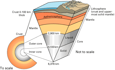 |
Structure of the Earth, courtesy USGS
|
As every school kid and parent knows by now at some level, the earth (right)
consists of
-
a very dense metallic core of iron-nickel
alloy divided into inner solid and outer liquid shells, which together
comprise about a third of the earth's mass and over half its 6,371 km mean
radius
-
a solid but variably viscous rocky mantle composed of less dense high-pressure
silicate minerals comprising over half the earth's mass and functionally
divided into upper and lower mantles by a fundamental physicochemical
barrier located globally at a depth of 660 km
-
a very
thin (6-100 km) and complex rocky (silicate) crust
at the surface, also divided functionally into brittle upper and ductile lower parts
-
a hydrosphere averaging ~5 km thick,
including all surface waters but overwhelmingly dominated by the oceans,
which contain 97% of the planet's unbound water
-
an atmosphere ~500 km thick
The layers have cooled, and
the upper mantle and crust have stiffened up considerably since then, but this basic
solid-earth structure has been in place since ~4.4 Ga.
This article focuses on the crust
and the upper mantle,
which together supply both the players and the playing field for plate
tectonics. Via climate, the hydrosphere and
atmosphere strongly influence surficial geologic processes like weathering,
erosion, sediment
transport, deposition and diagenesis,
isostatic rebound
and subsidence, but they're still passive players at the plate
tectonic level. The lower mantle contributes only gravity and some heat to the
process.
Largely isolated as it is from
surface processes by the profound thermodynamic and compositional barrier at 660
km, we can safely ignore the workings of the lower mantle here. And since the core contributes little to our story beyond
gravity and the geomagnetic field,
we'll ignore it entirely.
You'll find a concise summary of ^Earth's
physical attributes as a planet at Bill Arnett's ^The
Nine Planets site.
One More Division—the Lithosphere and Asthenosphere
| crust |
lithosphere |
| upper
mantle |
lithospheric
mantle |
| asthenosphere |
| "lower
upper mantle" |
| lower
mantle |
| core |
|
Compositional and mechanical layerings of the earth
|
In addition to the familiar compositional layering outlined
above, it's essential to recognize an overlapping mechanical subdivision of the planet
at depths above 660 km — into lithosphere,
asthenosphere and remaining upper mantle. These
overlapping boundaries make it hard to understand what
"upper mantle" means in some contexts, but I'll try to be as clear about
that as I can without adding too many extra words. Geoscience could really use
a short recognized term for "remaining upper mantle", or what the table
at right calls "lower upper mantle".
Since ~2.0 Ga, the
crust and the cool, stiff layer of mantle immediately
underlying it have moved together over the surface of the earth as a segmented but fairly coherent planetary shell called the lithosphere.
By definition, the layer of mantle that tags along with the crust is the lithospheric
mantle.
The plates of plate tectonics are nothing more than
mobile lithospheric fragments — some large, some small, some mostly oceanic,
some mostly continental, but all at least
oceanic in part. The plates slide around on a slippery, barely-solid, ready-to-melt layer
of upper mantle known as the asthenosphere that
leaks out to the surface whenever it can. Like it or not, we're along for the
ride
About 85% of the earth's surface can be understood in terms of
physical interactions among plates and between plates and the asthenosphere.
That is the fundamental lesson of plate tectonics. Colorado falls squarely in the
remaining 15%, where other processes, perhaps of mantle origin, also seem to
come into play.
Geothermal, Pressure and Density Gradients
The earth is a mighty heat engine constrained by its own gravity. To understand its workings, one must first
sort out how the temperature, pressure and the density of its materials vary with
depth.
Temperature
Temperature and pressure increase steadily with depth throughout the earth
but along different curves and more steeply at some levels and locations than at
others.
The geothermal
gradient, the curve describing the change of temperature with depth, reflects the cooling
of the earth. It's
fairly well known at most depths from well logs and geophysical observations,
including the behavior of planet-crossing seismic waves. The global average is ~25°C/km, but the observed range is
5-90°C/km. At shallower depths, the geothermal gradient is flatter and varies
considerably from place to place. For instance, at 10 km down, the temperature
is 300°C under Los Angeles but only 150°C under Pittsburgh.
Pressure
Pressure gradients in
the earth are also fairly well worked out, at least at some depths. At all
depths, the pressure is largely lithostatic—i.e., simply due to the
combined weight of all overlying materials. In the crust
and upper mantle, plate tectonic processes can vary pressure
a bit around lithostatic values—not by much, but enough to make a difference,
particularly vis-à-vis the asthenosphere's very tenuous hold on solidity. The
unthinkable lithostatic pressures found at lower mantle
depths severely suppress convection but foster chemical stratification.
Density
For the
most part, density also increases steadily with depth, particularly at the core.
There is, however, one all-important exception:
Unlike continental lithosphere, oceanic
lithosphere is nearly everywhere denser than the weak upper mantle
supporting it.
This gravitational instability, not mantle
convection, turns out to be the
prime mover of plate tectonics, as we'll see.
A Brief Thermal History of the Earth
The earth has been losing heat to space since it first formed but remains
very hot internally, even after 4.5 Ga of cooling. Major impacts during the Hadean Eon (4.5-3.8 Ga,
00:00-03:40 hours) provided significant setbacks early on, but the planet's been
cooling steadily ever since. The heat the earth now sheds into space comes from several
non-renewable sources:
Heat of the Earth
|
| Source |
Origin |
Timing |
|
Residual heat of
formation |
Gravitational, kinetic and thermal energy
deposited by early solar system debris falling into the forming earth via
impact heating |
One-shot deal largely complete by ~4.4
Ga, tailing off by ~3.8 Ga |
|
Chemical |
Differentiation and segregation of earth
materials into lower energy minerals and layers better suited to the
temperatures and depths to which they settled as the initially molten
planet sorted itself out |
One-shot deal ending ~4.4 Ga |
|
Radiogenic |
Decay of radioactive elements (primarily potassium, uranium and
thorium) concentrated for the most part in the upper mantle and
crust after ~4.4 Ga |
Ongoing but falling off steadily as the fixed
initial supply of radioisotopes decays away |
To put the importance of radiogenic heating into
perspective, note that the heat flux at the surface is ~10 times that across the
core-mantle boundary. Note further that radiogenic heat generation now is
probably 2-3 times less than it was in the Archean Era (3.8-2.0 Ga) due
to intervening radioactive decay.
Why bother with the cooling of the earth? Because processes in the mantle and
crust have evolved both quantitatively and qualitatively as temperatures have
fallen. Many high-temperature Archean processes have never occurred since,
including the formation of continental cratons
and their buoyant keels, the formation of domal granite-and-greenstone
complexes, the intrusion of large anorthosite bodies, and the eruption of ultramafic
komatiite lavas. These events required crust and upper mantle temperatures much
higher than today's.
|
Northern Pacific floor with Hawaii-Emperor and many other volcanic chains
|
Since ~2.0 Ga, most of the
heat escaping the earth does so through the oceans, primarily via seafloor spreading
(60%) and subduction.
These processes became possible only when the crust and
uppermost mantle had become cool and stiff enough to support continents standing high above ocean basins, and the upper
mantle had cooled enough to allow the gabbro-to-eclogite phase transition to
occur at a shallow enough depth (now ~60 km) to foster subduction. Without this
critical transition, which renders falling slabs of oceanic
crust denser even than the upper mantle below the asthenosphere, gravity
could not effectively drive subduction, and subduction could not effectively
drive plate tectonics.
The lower mantle has probably changed little
since its differentiation at ~4.4 Ga. Any residual temperature or density
contrasts left in the lower mantle at that time were effectively frozen into
place. It's circulation is very slow on time scales comparable to the current age of the earth,
never mind the time frames within which surface
processes evolve.
Top
Page Index
Crust
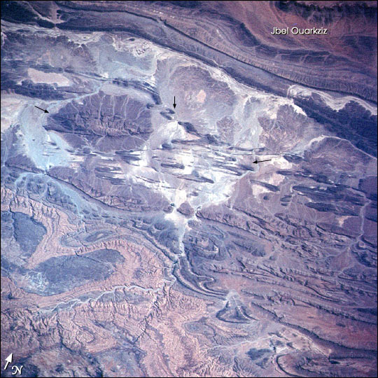
 |
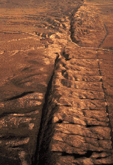
Anti-Atlas Mtn folds
|
Let's start our detailed dissection of the earth with its
most tangible layer, the crust. The crust is the
surface layer we inhabit and admire. It sits between
the atmosphere or hydrosphere on one hand and
the rarely exposed mantle on the other.
The accepted boundary
between the crust and mantle is the Mohorovicic
discontinuity, or Moho for short — a seismographic feature defined
primarily by an abrupt increase in the seismic wave velocity (~7 km/sec above and ~8 km/sec
below). Away from adornments like seamounts and submarine
basaltic plateaus, the Moho on oceanic plates
lies a fairly constant 5-6 km below the surface of the crust. On continental
plates, the depth to the Moho is all over the lot, with a global mean of ~30
km and a 5-100 km range. On the continents, the Moho also coincides with related
contrasts in consistency (stiffer below despite higher temperatures) and in the
abundance of high-pressure minerals (more olivine, pyroxenes and garnet below).
Types of Crust
On this planet, crust comes in four basic flavors— continental,
oceanic, arc-generated,
and collisional. Each type forms in a very
different way, with resulting differences in composition, structure and
mechanical properties.
Basement and Cover
Geologically, it's useful to divide the crust, whether continental
or oceanic, into basement and cover
layers. In most places, a stack of relatively thin, weak and easily-eroded sedimentary
or volcanic layers (the cover) blankets a much thicker substrate of hard, resistant crystalline
(igneous or metamorphic)
rock (the basement) extending down to the brittle-ductile transition if not to the Moho.
The basement is the foundation of the upper crust and the source of its
mechanical strength. It's generally fairly homogeneous and isotropic, meaning
that applied stresses find no particular directions or planes of weakness within
it away from identifiable faults and shear zones.
 |
Red Canyon cover and basement
|
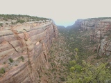
The shape of Red
Canyon (right) in the Colorado National
Monument shows how very differently cover and basement tend to erode. Red
Creek cut a wide and deep swath through the sedimentary cover (Wingate
Sandstone) at Red Canyon. The meager notch in the distance is the best it
could do in the hard 1.7 Ga Precambrian
basement flooring the canyon.
Oceanic Crust
Why
even mention oceanic crust in a web site about Colorado geology? For
starters, many of the exposed 1.7 Ga metamorphic gneisses and schists of the Colorado basement
derive from oceanic crustal elements caught up in the collisional crust formed
by the many ocean and backarc basin closures involved in
the Early
Proterozoic Colorado Orogeny. Some have been altered beyond
recognition by heat and pressure attending deep burial during collisions and
subsequent intrusions, but many retain
signatures of their oceanic ancestry—as we see, for example, in the 1.7 Ga metasediments and metavolcanics
exposed around the Mt. Evans batholith,
in the east wall of Tenmile Canyon, and in Painted Wall of the Black
Canyon of the Gunnison (right).
The Igneous Basement of the Oceanic Crust
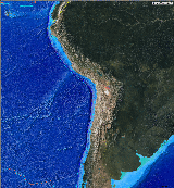 |
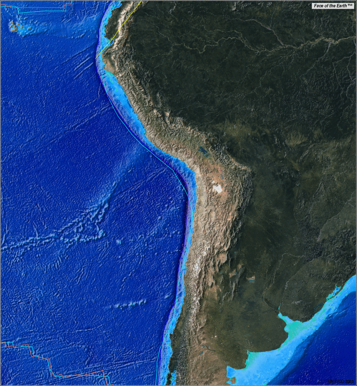
Oceanic crust off Peru and Chile
|
The plain crust flooring the abyssal plains of the oceans
is the simplest case. This predictable, mostly igneous 4-layer package is usually ~6 km
thick.
Structure of Simple Oceanic Crust
|
| Layer |
Description |
| 0 |
Relatively thin cover
of marine sediments on
top |
| 1 |
Submarine basalt
erupted onto the surface before the sediments accumulated |
| 2 |
Densely-packed vertical gabbro
dikes with in deeper basalt |
| 3 |
Solid gabbro and even more
mafic cumulates
down to the Moho |
Layers 1-3 make up oceanic crust's stable basement,
which rests in turn on lithospheric mantle. By mass, the gabbro predominates.
Volcanic appendages like seamounts, submarine
basaltic plateaus and aseismic ridges can
thicken Layer 1 by several kilometers.
|
Spreading center and subduction zone, USGS
|
On average, oceanic crust is 3-10 times thinner
than continental crust. A more mantle-like average mineralogy
also makes it much denser (~3,000 vs. ~2,700 kg/m3). High
magnesium and iron and low silicon and aluminum contents earn oceanic crust the compositional designation mafic,
after the chemical symbols for magnesium (Ma) and iron (Fe). On the whole, oceanic crust much more
mafic than the continental crust but less mafic than the
ultramafic mantle.
The stable oceanic basement forms simultaneously with its underlying lithospheric mantle at seafloor spreading centers
like the Juan de Fuca ridge at right. Together, these two layer make an oceanic
plate or slab. The slab's mantle layer thickens over time as chilled asthenosphere
freezes to its undersurface in a process called underplating,
but the basement changes little until the plate subducts.
The Many Fates of Oceanic Crust
Sooner or later, all oceanic crust subducts. The
oldest dated continental crust on earth contains ~4.2 Ga zircons, whereas the
oldest crust on the ocean floor today is only ~180 Ma old. The average
surface dwell time for oceanic crust is a mere ~100 Ma. Satisfactorily
explaining these vast age differences was an early plate tectonic triumph.
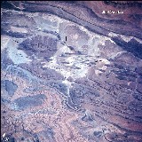
 |
Marine limestones atop the high Andes in the Pachapaqui mining
district
|
Varying
amounts of Layer 0-1 sediments and basalts get scraped into accretionary
wedges during subduction, but much of the sediment goes down with the ship. Occasionally, more complete scraps of oceanic crust called ophiolites
manage to escape subduction via subduction zone collisions,
which can also elevate thick Layer 0 sedimentary
packages like those found on outer continental shelves and
slopes to great heights, as in the Andes at left. For the most part, however,
subducted oceanic crust just falls back into the upper mantle
along with its underlying lithospheric mantle. At a depth
of ~60 km, the basement's basalt and gabbro undergo a phase change to eclogite,
a metamorphic rock of even greater density. The density kick then accelerates the plate's fall like a sinker
on a fishing line.
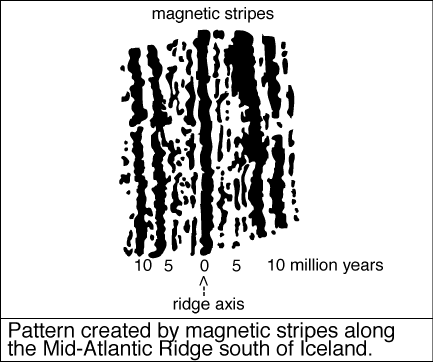
Remanent Magnetization
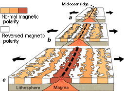 |
Magnetic stripe generation, USGS
|
The easily magnetized oceanic crust functions much like the magnetic coating
on a recording tape. (In this analogy, the lithospheric mantle is the tape's
plastic base.) Magnetic orientations frozen into cooling mafic basement minerals at the spreading center record
the plate's time and place of birth relative to
the prevailing geomagnetic field, which reverses at irregular intervals of
~0.5-10 Ma for poorly understood reasons. The field reversals create striking
magnetic stripes in the oceanic crust, as diagrammed at right.
Geoscientists have made great use of the remanent
magnetization of the ocean floor by cross-referencing its patterns against
a hard-won timetable of
geomagnetic field reversals. In
fact, magnetic mapping of the sea floor first cracked open the plate tectonics
revolution in earth science back in the early 1970s.
The Marine Sedimentary Cover
Freshly formed basalt-covered oceanic basement
is bare. It acquires
a sedimentary cover as it rafts
away from its spreading center of origin. The sediments
provide a variably detailed record of the travels and encounters of the plate on
which they amass. In well-developed, sediment-starved deep ocean basins like the
Atlantic, the sedimentary veneer rarely exceeds a few hundred meters in thickness. Uninterrupted accumulations of pelagic (deep ocean)
sediments like radiolarian chert record time spent on the abyssal plain,
far from land and well below the carbonate compensation depth, where
sinking calcareous marine animal skeletons (those made of calcium
carbonate) dissolve back into sea water, usually ~4 km down.
 |
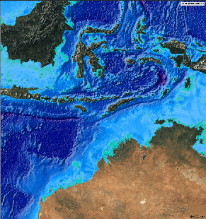
Sumatra and its necklace of forearc ridge islands stand high above the
Sunda trench to the southwest.
|
Terrigenous (land-derived) sediments
on oceanic crust tell of formation or passage near
an eroding landmass. Continental shelves are thick sedimentary
sequences piled
for the most part onto faulted continental crust at the
passive margin of a successful continental
rift, but they sometimes advance over oceanic crust, as they do along the
margins of the Red Sea. Volcaniclastic sediments resting on oceanic crust identify
the nearby landmass as a magmatic
arc. Large,
mature oceanic arcs like Sumatra
(right) can shed
substantial shelf-like sedimentary aprons onto oceanic crust in both forearc and
backarc settings.
Turbidity currents are the prime movers of
terrigenous sediments onto oceanic crust. They're also the prime carvers of the
submarine canyons found in river deltas, continental shelves and
other sedimentary aprons. Turbidity currents form when coastal waters heavy with
silt periodically roil down submarine canyons or along trenches to spread their loads onto
the deep ocean floor in large volumes, sometimes over distances of hundreds of
kilometers. For example, turbidity currents coming off the Ganges-Brahmaputra
delta at the north end of the Bay of Bengal carry sediments along the Sunda
trench as far south as Bali. The resulting distinctive sedimentary rocks, called turbidites,
contribute heavily to accretionary wedges at subduction
zones and also to continental slopes, particularly around the mouths of
major rivers.
Continental crust
Hydrated low-density sialic (silicon- and aluminum-rich) crustal residues floating on a global ocean of dense
hydrated mafic (magnesium- and iron-rich) magma probably developed
shortly after the time of
earth's formation at 4.5
Ga and
may have persisted well into the Archean Eon. Buoyant patches of sialic crust eventually
coalesced into a number of large, durable, unsinkable rafts that became the
cratons (stable cores) of our modern continents — e.g., the Wyoming
Province and the Canadian shield. Through fractionation and
underplating of subjacent mantle, these early Archean cratons
developed thick (>100 km) hulls and very deep (>250 km) keels of cool, strong,
buoyant and refractory
lithospheric mantle that to
this day protect them from disruption by heat and currents in the underlying upper mantle.
Most of the planet's supply of sialic continental crust formed in the hot
early Archean
via high-temperature processes never repeated since.
Much of that crust was recycled into the upper
mantle prior to the advent of plate tectonics at ~2.0 Ga. The remaining
Archean cratons have been tied up in continental cores ever since. Continental crust
formed since 2.0 Ga, primarily at post-Archean collisional
and convergent plate boundaries, has been
much more mantle-like (mafic) than the surviving
Archean cratons.
BTW, Colorado contains no cratonic crust to speak of, but adjacent Wyoming
is a different story.
Relative to oceanic crust, the crust found in
cratons is usually much lighter (~2,700 vs. 3,000+ kg/m3),
much thicker (for the most part, 20-60 km vs. ~ 6 km) and much more complex with regard to
both structure and composition. Continental crust is typically composed of crystalline
igneous and
metamorphic rock at
depth and all manner of sedimentary, igneous and metamorphic rocks near the surface.
On average, sialic continental crust contains much more silicon and aluminum and much
less magnesium and iron than the mafic oceanic crust and the
ultramafic mantle.
Rocks of this composition are said to be felsic, because they contain
abundant feldspars (K, Na, Ca, Ba, Rb, Sr and Fe aluminum-silicon oxides) and
silica (Si02).
Upper and Lower Crust
Mechanically, continental crust divides into a cooler, stronger, brittle upper crust
and a hotter, weaker, ductile (putty-like) lower crust. An important thermodynamic
and mechanical boundary known as the brittle-ductile transition
(BDT) separates the upper and
lower crust, usually 10-15 km below the surface. The
terms middle crust and mid-crust usually refer to a horizon around
the brittle-ductile transition.
The hot,
plastic ductile lower crust flows, slowly of course, under the influence of gravity and regional
stress fields, just as an incandescent but quite solid steel ingot flows to take on
the shape of a I-beam under the force of a hydraulic roller press. The
less compliant brittle upper crust folds, buckles and snaps when stressed beyond its
limits but is nevertheless the main locus of mechanical
strength
in continental lithosphere. The upper crust generates most of the world's earthquakes, but the lower
crust can get into the act now and then, too. Below the Moho,
the ductile mantle is itself seismically silent. All subcrustal earthquakes originate in still-brittle
slabs of oceanic
crust falling through the upper mantle below subduction zones
but above the "660", the effectively impenetrable
physicochemical boundary between the upper and lower
mantle. Claims of earthquakes (and therefore brittle behavior) below the
"660" are based on highly suspect data.
Over most of the globe, the upper crust further divides into cover
and basement layers, each with markedly different rock types
and mechanical properties. The strength of the upper crust and to a large
extent, that of the entire continental lithosphere,
resides in the basement. The cover may have its own secondary
BDT, but it's the primary basement BDT that separates the upper from the
lower crust.
Arc-Generated Crust
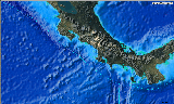 |
Costa Rican arc
|
We'll examine this important intermediate form of crust in detail when we
discuss the magmatic arcs that accompany subduction
below. Suffice it to say here that arc-generated crust is complex and highly
variable but on average falls somewhere between mafic and felsic in composition. The Colorado basement
includes a substantial portion of metamorphic
arc-generated crust of Early
Proterozoic age. At right is the Costa Rican magmatic arc
built on the southwest margin of the Caribbean plate, where the Cocos and
Nazca plates subduct along the dotted cyan line.
Collision-Generated Crust
 |
Much of the western 3rd of the US has been accreted in plate-margin
collisions just in the last 500 Ma
|
Continents add mixed crustal materials at or near their margins through
subduction zone collisions of all kinds. Over deep time, long-lived continental
arcs can accrete substantial volumes of arc-generated crust of
intermediate mafic-to-felsic composition, fragments of partially subducted mafic aseismic ridges,
submarine
basalt plateaus and ocean islands,
slivers of mafic oceanic
crust and occasional felsic continental fragments (e.g., ribbon continents) as they scrape or break
these buoyant incoming structures off falling slabs. Between mid-Paleozoic
and Late Jurassic time, North America grew by a third or more along its western
margin through the accretion of many such far-flung exotic terranes, some of which
traveled north 3,000 km or more to become California, Nevada and parts of Alaska and
Utah.
 |
The Sea of Japan is a classic backarc basin separating the
Japanese and Islands from the Asian mainland. The Sea of Okhotsk (between
the Kuril Islands and the mainland), however, is more like a large
continental graben.
|
Lesser collisions at continental arcs many not result in terrane accretion,
but they can still generate complex crust by crushing backarc
basins and arcs together. Submarine basaltic
plateaus and aseismic ridges can subduct
successfully if not gracefully. Their buoyancy can generate enough compressive
stress in the overriding plate to close and invert a backarc
basin like the Sea of Japan (right) and can even mix the arc itself back
into the resulting orogen. A new arc may then form outboard of or sometimes over the mess created by the
collision. In fact, backarc basins can form and close repeatedly,
accordion-like, along the same
continental margin in a process known as tectonic switching. Backarc
basins are important nurseries for collisional continental crust.
Continent-continent collisions may also entrap
exotic terranes other oceanic elements as they close both ocean and backarc basins in complex time-progressive patterns along
strike.
Mobile Belts
However they form, these mixed-bag continental add-ons, called mobile
or orogenic belts,
can produce extraordinarily thick, complex and puzzling crustal structures and
juxtapositions overprinted by metamorphism
varying widely in both degree and P/T regime. Things get even crazier when erosion
and later deformations and magmatic events begin to
tamper with the evidence. Between 1.78 and 1.65 Ga, the Colorado
Province quickly grew into a large and very complex mobile belt through
backarc mashing and the accretion of many primarily oceanic terranes. Nearly 1.7
Ga later, after long bouts of deep erosion and several major superimposed
deformations and intrusions, most of its pieces are hopelessly scrambled into
the basement, and some are missing or metamorphosed beyond recognition.
Nevertheless, basement exposures like those in sections of the Black
Canyon of the Gunnison occasionally preserve enough original structure and
composition to give an idea of what went on.

|
|
|
To get an even better feel for what students of Colorado's Precambrian past
are up against, take a look at the modern Banda Sea (right), which contains many
oceanic elements and a few continental fragments as well. As Australia advances
on Southeast Asia, the sea will close, probably in the next
10 Ma or so. Geologists studying the resulting suture 50 Ma from now will have a heck of a time unraveling all the
pieces, even without further tectonism. I wish them luck.
Why Mobile?
Mobile (orogenic) belts are less stable than the cratons
they encrust for a number of reasons. Structurally, they're usually on thinner
lithosphere, even when they include thickened crust, because they lack the deep
refractory keels that insulate cratons from potentially
disruptive upper mantle heat and currents. As a natural consequence of their creation
in collision zones, they tend to be hotter and more densely and thoroughly
faulted, with more built-in zones of weakness of lithospheric scale. Their
greater compositional diversity can include weaker materials, and on average,
they're more mafic and therefore less buoyant
relative to the asthenosphere. As a result, they're more likely than cratonic
crust to pass from continent to continent in the supercontinent
cycle, or to disappear down a continent-continent
subduction zone, temporarily or permanently. That's why they're called mobile.
The Crustal Economy
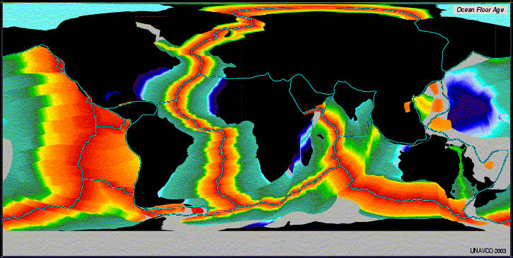
 |
Ocean floor ages; red ~ 0-10 Ma, purple ~ 160-180 Ma
|
Nearly all of the planet's oceanic crust gets recycled
through the upper mantle via the processes of subduction
and seafloor spreading. Oceans as we know them have been around since at
least ~2.0 Ga and probably in much shallower form since at least 3.5 Ga, but nowhere is
today's oceanic crust older than ~180 Ma. With the exception of a few slivers (ophiolites) squeezed into mobile
belts here and there, all older oceanic crust has been returned to the upper
mantle by subduction. The average surface dwell time for oceanic crust is a mere
~100 Ma.
Continental, collisional
and arc-generated crusts are a much different story.
They're too
buoyant to subduct in any significant quantity (try pushing a basketball underwater), so
they're usually left behind at the surface at subduction zones, where they
generate more collisional crust. They get passed back and forth among the continents du jour as the plates do
their dance in the supercontinent cycle. Continental
mobile belts are particularly susceptible to exchange
among the seldom-rifted continental cores of ancient cratonic
crust, but the cores change partners among themselves. The oldest
exposed continental crust, part of such a core in southwest Australia, dates back to 4.2 Ga.
The continents slowly lose crustal mass "off the top" to minor
subduction of the marine sediments they shed, but most of their eroded materials
are simply redistributed and recycled into different continental crust via
processes ranging from sediment transport and deposition
to the formation of collisional crust to the
supercontinent cycle. Total continental area has grown slowly since the
inception of plate tectonics at ~2.0 Ga through the formation of mobile
belts, primarily by way of arc magmatism and backarc
spreading.
Top
Page Index
Plates and Mantle
The earth's outermost shell, the lithosphere, is segmented into
semi-rigid mobile
plates that give the planet its facial expression. The plates are fairly
rigid internally, particularly around the ancient continental cores known as cratons, but are
variably deformable at their
margins. At times, plates also deform far inboard, as
the Rockies and the Colorado Plateau loudly testify.
In aggregate, the plates form a self-organizing, far-from-equilibrium
dissipative system driven only by gravity and the top-down cooling of the earth,
subject to spontaneous reorganization without notice on long and short time
scales and on large and small distance scales. In other words, the plates behave
chaotically in the mathematical sense of the term. The upper
mantle moves primarily in response to the motions of the plates, not the
other way around, as originally thought. Interestingly, there
always seem to be about 12 roughly pentagonal major plates, with many minor
plates filling in the gaps.
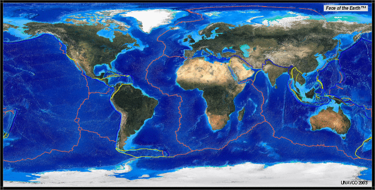
 |
Modern tectonic plates, USGS
|
Plates (like the Pacific) that include
subducting oceanic lithosphere are the freest to
roam, and they contribute most to the changing face of the earth over time. Most
plates lack subducting boundaries, however. Their
wanderings are heavily restricted by the motions of adjacent plates. Together, the plates form a global circuit of mutually related motions that can get
pretty complicated at times.
You can watch the plates
dance to the beat of gravity through time in the animations at the ^PALEOMAP
Project. You can examine the plates and their current relationships in
many fascinating ways at the Jules
Verne Voyager, Jr. interactive mapping site, where I produced the map at
right.
Lithospheric Mantle and Asthenosphere
| |
Structure of the Earth, USGS
|
Plates carry their
crust on a relatively cool, stiff basal layer of outermost solid mantle called the lithospheric mantle,
simply defined as the portion of the upper mantle that moves in lockstep with
the crust. Together, the crust and lithospheric mantle make up the lithosphere.
The table below may help you sort out these overlapping divisions of the earth.
The lithospheric mantle slides around on a very hot, barely solid, highly deformable upper mantle layer
known as the asthenosphere, from the Greek for "weak shell". Extending down to a depth of ~200 km, the
unstable asthenosphere is ready to melt at the slightest provocation. More
often than not, the excuse is relief of lithostatic pressure (depressurization) secondary to
extension within or between plates,
as at spreading centers and subduction zones.
The strong global
concentration of volcanoes along plate boundaries is no accident.
| crust |
lithosphere |
| upper
mantle |
lithospheric
mantle |
| asthenosphere |
| "lower
upper mantle" |
| lower
mantle |
| core |
|
Compositional and mechanical layerings of the earth
|
Compared to the stiff,
groaning crust, the lithospheric mantle is weak and
seismically silent, and the asthenosphere is like so much grease under the skids.
Plate Strength and Isostasy
Mechanically speaking, a plate's strength (i.e., its ability to resist
deformation and fracture under tensile, compressional and bending stresses) resides in its stiff
upper
crust—the only portion brittle enough to generate earthquakes. The weaker, ductile
lower crust and
lithospheric
mantle (slightly stiffer and denser than the lower crust but still weak relative
to the upper crust) are supported by the hard shell of upper crust in exactly
the same way that a crab's exoskeleton supports its soft internals. The hot asthenosphere
is too plastic to support much of anything except by buoyancy, but since all continental
lithosphere literally floats on the asthenosphere, that's no small contribution.
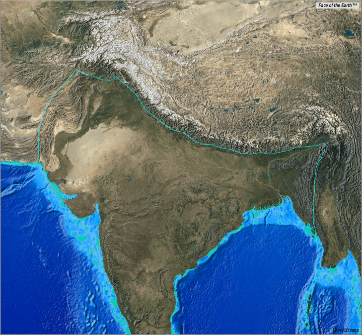
 |
Himalayan orogen
|
Plates support large mountain ranges in 2 main ways—through flexural
strength and through buoyancy. The diving board's flexural strength supports the diver at its
tip as she gathers herself, eyes closed and motionless. In the same manner, the flexural strength of the thick upper crust of the partially subducted
northern margin of the Indian plate supports the soaring height and immense
weight of the Himalayas and the Tibetan Plateau (top center at right), both of which stand on
the shattered and
weak overriding southern margin of the Eurasian plate. Without the flexural
support of the Indian plate, the Himalayas would sink and drown in their own
sediments.
The majority of mountain ranges not associated with continent-continent
collisions receive little flexural support from surrounding crust. Instead,
such ranges support their
locally thickened crust through buoyancy relative
to denser rock below. Once you take to heart the viscous behavior of rocks below
the upper crust, this is nothing more than a straightforward application of
Archimedes principle. Isostasy is
a fancy name for the obvious requirement that
Down to at least the asthenosphere, every square kilometer column of
rock must weigh the same in the absence of external (e.g., flexural) support.
Otherwise, lithostatic pressure differences would force denser, more ductile
rock below the upper crust to flow into underweight columns until the pressures
equalized.
 |
Andean orogen
|
Since earth materials are too weak and earth processes too slow to generate
dynamic (tectonic) overpressures large enough to override isostasy, it follows that
equally large roots
of light-weight crust should underlie and buoy up all mountain ranges lacking
flexural support. Most ranges not associated with continent-continent
collisions have geophysically detectable roots within the crust—among them the Andes (right) and the Sierra
Nevada but not the Rockies.
Note: To understand isostasy, think of a coal barge. The higher
you heap the coal, which is less dense than water in aggregate, the lower the barge sits in the water. The submerged portion
is the root. As long as the barge floats freely, it has only isostatic (buoyant)
support. If the barge were tightly cabled into a large raft of barges, it would
then receive some flexural support from adjoining barges via the cables. If it
were pulled across the water at high speed, it would also receive dynamic
support via inertial forces exerted by the water.
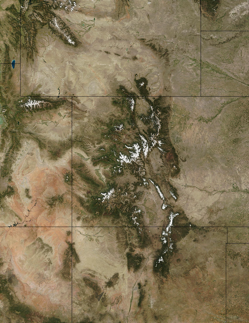
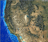
So What's Up With the Rockies?
 |
Four Corners from space, NASA
|
The Rockies seem to be a very peculiar case here. They now stand at great
average elevation over 1,000 km from any plate margin without any crustal roots or flexural
support to speak of, and have done so in the face of erosion for perhaps some 70
Ma—quite a long time as mountain ranges go. In fact, they're as high as
ever and still rising!
What keeps them up then? The best bet is isostasy operating at upper mantle
rather than at the usual crustal levels. A large
low-velocity upper mantle seismic anomaly (the Aspen
anomaly) underlying the central Rockies is widely interpreted as a zone of higher than usual
temperature. What that means is far from clear, but if lower seismic velocities also mean
lower densities, as they should at the depths involved, then the upper mantle may be
providing deeper than usual buoyant support for the Rockies. Dynamic support
by a regional upwelling of the upper mantle (an inertial "jet" effect)
is unlikely. Intraplate
disturbances have repeatedly rumpled this portion of the continent for at least
1.4 Ga, since the time of the Berthoud
Orogeny. That kind of time frame also raises the question of a
long-standing lower mantle influence. More at 11...
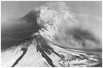
Plate Failure and Volcanism
|
Northern Pacific floor with Hawaii-Emperor and many other volcanic chains
|
Whether continental or oceanic, plates have little tensile strength. In
other words, they resist compression fairly well but pull apart easily. Most if
not all large volcanic outbursts (hot spots) result,
not from mantle outbursts and thermal anomalies, but from the failures of plates in tension. Indeed,
the plate need not crack overtly; all that's required is a horizontal axis of
least compressional stress. (This is known as the diking condition.) Once
it gets a foot in the door, the buoyant force behind a depressurization melt does most of the
work involved in breaching the plate. A single meter-wide dike can spew out
tremendous volumes of lava in geologically short timeframes. In all likelihood,
the intense and widespread pulse of magmatism
that swept Colorado in the mid-Tertiary resulted, at least in part, from
regional extension associated with the passing of the Rio
Grande Rift.
As your read on, keep this firmly in mind:
The near-molten asthenosphere is barely contained by the lithosphere.
It will leak out as melt wherever and whenever it can, with little provocation.
Spreading centers like the Mid-Atlantic Ridge and the
East Pacific Rise; ocean islands
like ^Iceland and the ^Emperor-Hawaiian
chain; flood basalts like the Snake River
Plain and the ^Deccan Traps of
India; leaky faults like the San Andreas
transform and the many normal faults of the Basin and Range; massive
intraplate volcanic disturbances like ^Yellowstone;
and vast
oceanic plateaus like the Ontong Java all owe their existence to this
fundamental fact of life on planet Earth. What comes out depends critically on
how thoroughly the asthenosphere melts and on what the melt passes through to
reach the surface, but basalt is the
quintessential leakage lava, especially in oceanic
settings.
The Upper Mantle and the (Nearly) Impenetrable "660"
| |
Structure of the Earth, USGS
|
The lithospheric mantle and the asthenosphere
are the uppermost layers of the upper mantle,
which ends at depth at the "660"—the fundamental upper-lower mantle
boundary found globally at 660±30 km. An obvious discontinuity in seismic
probes of the mantle, the 660 appears to represent a solid-solid phase
transition localized at 660 km by relatively fixed temperature and pressure gradients.
In the diagram at right, the 660 runs along the top of the yellow lower
mantle. The more complex upper mantle consists of a basal layer (salmon), the
mobile asthenosphere (orange) and the plate-bound
lithospheric mantle (gray).
Due to a number of mutually-reinforcing physicochemical influences, material
has a very hard time crossing the 660 in either direction, if it crosses at all. This
barrier has profound
implications for earth dynamics. For starters, it means that
All plate tectonic processes play out in the crust and the upper
mantle above the 660.
Subducted
oceanic lithosphere drops through the upper mantle and piles up along the 660
to await
recycling.
If the the lower mantle convects at all, it does so very slowly in isolation below the
660, passing heat to the upper mantle only through conduction. Observed and
inferred currents in the
upper mantle derive primarily from plate motions and from small-scale convection
cells related to plate boundaries, not from currents in the lower mantle.
The Fertile Upper Mantle
Thanks to the self-organizing plates, the upper mantle is heterogeneous in
both temperature and composition. It has absorbed a great deal of oceanic
lithosphere since the onset of plate tectonics at ~2.0 Ga, and it absorbed a
good deal of felsic Archean crust before that. As a result, it remains rich in
volatile elements (C, H and O) and also in fertile minerals (those with low
melting points). Among other things, these constituents make the asthenosphere—a
key player in both plate tectonics and intraplate volcanism—all the more eager
to melt and the deeper upper
mantle less dense than sinking slabs of oceanic crust. We'll return to the upper
mantle many times as this overview of earth dynamics unfolds.
The Silent Lower Mantle
By far, the lower mantle's greatest contribution to observable geologic
processes is the gravity generated by its immense mass—well over half that
of the planet. Since gravity is main drive in most surface processes, including
plate tectonics, gravitational collapse, mass wasting, erosion and sediment
transport, that's no small matter, but the lower mantle's influence pretty
much ends there.
The lower mantle appears to be stratified chemically, with likely boundaries
at 1,000 and 2,000 km. If it convects, it may do so very slowly in several
layers isolated from each other and also from the upper mantle and
crust. Having
lost most of its heat-generating radioactivity to the
crust and upper mantle in the planet's thorough chemical differentiation prior
to ~4.4 Ga, for most of earth's history, it has passively conducted original
heat amounting to only ~10% of the surface flux from the core to the upper mantle with
little help from convection.
Can lower mantle features have surface expressions? Theoretically, density
lows in the lower mantle should lead to broad topographic highs at the the surface,
while temperature highs should heat the overlying upper mantle with potential
effects on plate distribution. At lower mantle densities, viscosities and
thermal expansion rates, any such contrasts
should be very large and semi-permanent. No such associations have been
documented, but I wonder about the curiously rootless
Rockies, which lack a demonstrable means of support.
Narrow-based "plumes" of hot material rising
directly from the core-mantle boundary to manifest as surface hot
spots are physically impossible, despite many educational cartoons and
professional publications to the contrary. These plume proponents ignore the
convection-stifling effects of pressure on thermal expansivity, viscosity and
thermal conductivity at planetary scale. Add the pressure back into the models,
and plumes don't form. Nor have any such plumes been detected by geophysical
means.
Since the lower mantle has nothing else to do with plate tectonics, and
certainly nothing to do with mantle plumes or hotspots, we'll ignore it
henceforth.
BTW, an excellent up-to-date online read on the role of convection in earth
dynamics is ^Mantle
Convection by renowned geophysicist Don Anderson. If you fancy plumes,
be prepared to change your mind.
Who's Counting?
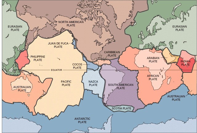
 |
Plates with color-coded boundary types
|
Since 2.0 Ga, the plates have clumped and split and regrouped many times, but
by most counts, there are currently 20 plates—12 major and 8 minor. The 7 largest plates now account for 94% of the earth's
surface, oceans included, and the smallest of the 12 major plates is larger than
all of the minor plates combined.
The observation that there
always seem to be ~12 major plates in the geologic record suggests that a
dodecahedral division of the lithosphere involving 12 roughly pentagonal plates may be
energetically and statistically favored over time. Experimentally and
mathematically, there are only so many good ways to crack up
and move a spherical shell held together by gravitationally-induced lateral
compression, which acts something
like surface tension.
In the case of the earth, the weight of the plates and their willingness to spread
under gravity at free margins (AKA subduction zones)
together provide the lateral compression that keeps plates in contact.
Top
Page Index
Plate Motions
|
Pangea, complete and during break-up
|
To understand why plates move, consider these geometric and
physical constraints on plate tectonics:
-
Since the earth's size and shape seem to have
been stable since the planet's formation at 4.5 Ga, available surface area
is constant. The plates have only so much room. If some plates grow, others
must lose an equal area, at least at the surface.
-
For a variety reasons, gaps between plates are
simply not sustainable. For starters, the asthenosphere
on which the plates rest is too plastic and too close to its melting point
to stay out of any gap that might develop. In fact, there's a name for
asthenosphere that manages to "plate" itself out onto the surface:
Oceanic lithosphere.
-
Gravity impels lithospheric plates to move
toward any free edge unrestrained by other plates.
-
The only truly free edges available in the
system are at subduction zones where an
oceanic plate segment (which may or may not have attached continental
segments) manages to slip beneath the edge of another plate.
Oceanic plate segments move toward their subduction zones because they are
under constant compression, both by their own weight and by neighboring plate
segments, and simply have no place else to go. Overriding plates at such
subduction zones move or stretch toward the subducting plates as the latter fall
out of their way. Through these simple local interactions, the plates enter a ^self-organized
dance in the same way that shoals of fish manage to dart in unison without a
leader.
You can watch the plates dance through time in the online animations at the
^PALEOMAP
Project.
Planetary Rotation and Mantle Convection
 |
Earth, NASA
|
The earth's daily rotation
appears to energize, or at least foster, plate motions to
some extent. On average, relative plate velocities near the equator are double
those near the poles. This stable pattern and the net westerly drift of
lithosphere apparent in the Antarctic frame of
reference together strongly imply an input from the
planet's spin.
Convection Can't Do the Job
Slow convective circulation of hot, plastic mantle rock is often said to be
the energy source powering the dance of the plates, but many lines of
geophysical evidence rule that out. Upper mantle convection certainly occurs in
small scattered cells, but it doesn't exert
enough horizontal force on the lithosphere to push plates around. In fact,
upper mantle currents result
from plate motions, not the other way around. Lower convection, if it exists, is confined below the
"660" and is thus effectively decoupled from the upper mantle and
lithosphere. Heat rising from the lower mantle enters the upper
by conduction, not by convection.
The bottom line:
Top-down cooling and gravity acting on oceanic lithosphere are the only documentable
driving forces for plate tectonics, perhaps with a slight boost from planetary
rotation.
Reference Frames
Relative plate motions are the most
important because they control plate interactions directly. Absolute plate motions
are also of interest, but they're difficult to pin down for lack of a
suitable reference frame. Of the many possible frames proposed, the most commonly
used are the hot
spot frame pegged to Hawaii or to a collection of selected "fixed"
hot spots (on the assumption that the proposed underlying mantle plumes
must be fixed relative to the mantle), and the "no net rotation" (NNR) frame
designed to minimize all plate motions. But hot spots turn out to migrate at
rates (3-6 mm/year) comparable to plate velocities, and the NNR frames assign
plate velocities and relative motions that just don't jibe with observed plate boundary types. In
other words, plate velocities don't necessarily point toward convergent
boundaries, away from divergent boundaries or along transform boundaries, as one
would expect.
The Antarctic Frame
 |
Antarctic frame
|
A simpler and more realistic frame plots recent plate motions against a fixed Antarctica
(right) since, more than any other plate, it has boundaries that are
nearly all divergent. (The only exception involves the
tiny Scotia plate east of Cape Horn.) In the Antarctic frame, all slab
hinges roll back (as they must), all ridges migrate (to tap fresh
asthenosphere) and plate
velocities actually point toward convergent plate
boundaries, away from divergent
boundaries and along transform boundaries, as they
should. You can give the Antarctic and other frames a try online at the Jules
Verne Voyager, Jr. interactive mapping site.
Rigid, Mostly
 |
Tibetan Plateau
|
For the most part, the plates move as rigid bodies over the sphere of the
earth along fairly sharp boundaries and interact and
deform primarily along those boundaries. But significant areas of intraplate deformation
affect 15% of the earth's surface, including much of Asia within and around the
Tibetan Plateau (right).
The Rockies and the Colorado Plateau fall squarely in that 15%
minority,
thanks in part to a 1.6 Ga-long legacy of
weakness in the Colorado basement.
Mantle stirrings probably also play a role in the Rockies, but relevant data is
hard to come by. Intraplate deformations remain an active and
challenging area of
research in contemporary geoscience.
Top
Page Index
Plate Boundaries
|
Plates with color-coded boundary types
|
The plates are semi-rigid spherical caps with varying shapes and sizes at the
earth's surface. On a planetary scale, most plate boundaries are surprisingly
sharp, but some are diffuse—in some cases, up to hundreds of km across. The
boundary around any one plate may vary in character from place to place, but the
nature of one plate's boundary with any other single plate is in large measure dictated
by the relative motion of the two plates involved. Plate boundaries are
therefore predominantly one of three basic types—divergent,
convergent or transform.
Currently, 80% of the earth's plate boundaries are
divergent mid-ocean ridges and convergent subduction
zones. As the globe at right shows, most boundaries are on the ocean
floors, and this is no accident: By weakening rock and promoting melting, water
tends to facilitate plate interactions.
Divergent Boundaries
 |
Mid-Atlantic Ridge
|
Plates move away from each other at divergent
boundaries, most of which are seafloor spreading centers. Mid-ocean ridges like the Mid-Atlantic ridge shown at right are the purest and most developed examples of
divergent plate boundaries, but less oceanic examples include the Red Sea
and the Gulf of California. Divergent boundaries create all of the planet's oceanic
lithosphere.
Convergent Boundaries
|
Himalayan orogen
|
Plates move toward each other at convergent
boundaries. Subduction zones and collision belts mark convergent boundaries,
depending on the lithospheric types involved. Most convergent boundaries
involve oceanic lithosphere on at least
one side, but continent-continent convergences make for some of the planet's
most dramatic scenery, including the Himalayas (right) and the Alps.
Transform Boundaries
 |
San Andreas Fault
|
Plates slide past each other horizontally along transform
boundaries, or transforms for short. Over time, transforms have been
responsible for many large-scale redistributions of continental
crust. California's San Andreas fault is the
main locus of motion (5 mm/yr) between the Pacific and North American plates, but
their
rather diffuse transform boundary also includes faults far to the east
beyond the Sierras. At right, the main trace of the San Andreas fault
rumples up the Temblor Range across central California's Carrizo Plain.
Mixed Boundaries
 |
Complex Pacific-North American boundary, USGS
|
Things can get pretty messy after 2.0 Ga of semi-rigid plates bumping and grinding
helter-skelter on the surface of a
sphere. Mixed plate boundaries tend to occur where the margins and relative motions of
the two plates involved fail to align neatly.
In California, the Pacific-North American
boundary is both diffuse and mixed. In its drive to the NW relative to the California margin of the North
American plate, the Pacific plate must also pull away to the west
as it slides along the San Andreas fault, which trends too much to the north to
accommodate the relative plate motions cleanly. Since plates lack the
cohesion to allow gaps to open up between them, ongoing Basin and Range
extension carried by gravity-driven lower crustal flow accommodates the westward
component of divergence along the predominantly transform Pacific-North American
boundary.
Triple Junctions
 |
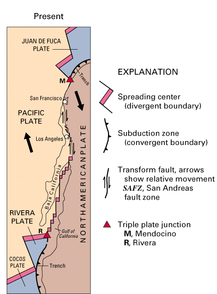
Mendocino Triple Junction
|
So far, we've considered only boundaries involving two plates. The coming together of three plates is called a triple junction, the ridge-ridge-ridge
(RRR) variety being the most common. Eventually, all plate boundaries end at triple
junctions, as do all seams on a soccer ball. California's Cape Mendocino (right)
marks a seismically dangerous
trench-transform-transform triple junction terminating the Gorda Trench, the San Andreas
Fault, the Mendocino Fracture Zone.
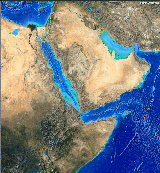 |
Afar Triple Junction
|
Most
RRR triple junctions are oceanic, but the Afar triple junction of
Ethiopia and Somalia is a notable exception. Particularly leaky oceanic RRR
triple junctions are the most common source for the seamounts
and large submarine
basaltic plateaus that dot the ocean basins.
Triple junctions exhibit many other surprising behaviors,
but they're not a
significant part of Colorado's story and won't be discussed further here.
Note: Quadruple and higher-order junctions don't seem to occur and wouldn't be expected for a
number of basic physical and geometric reasons related to the way things tend to
play out on spherical surfaces.
Top
Page Index
Lithosphere
|
Structure of the Earth, USGS
|
The
earth's mobile lithosphere consists of the crust and the
chilled topmost layer of the upper mantle. These two layers are usually
inseparable, but the lithospheric mantle can occasionally peel off (delaminate),
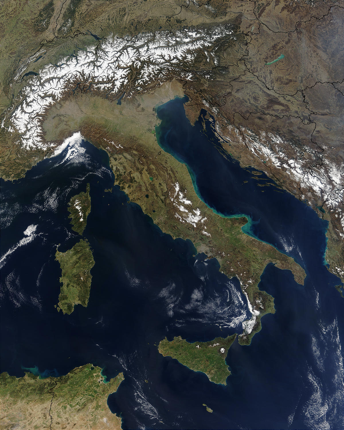
as it is doing now beneath the Carpathian Mountains of the Southern Alps. The plates
of plate tectonics are lithospheric rafts that glide across the surface of the
planet on the barely solid, plastic asthenosphere.
Like crust, lithosphere comes in two basic end-member flavors, continental and
oceanic, but intermediate forms
occur,
particularly at passive continental margins. Most plates include both
continental and oceanic lithospheric components.
Relative to the upper mantle on which it floats, continental
lithosphere is buoyant and unsinkable. Oceanic lithosphere, on the other hand, is
both denser and
stiffer than the underlying mantle and will sink at its first
opportunity.
This is the fundamental fact of plate tectonics.
Oceanic Lithosphere
|
Mid-Atlantic Ridge
|
Geoscientists call oceanic segments of lithospheric plates slabs for short,
and I'll do the same. Slabs are created at seafloor
spreading centers and consumed at subduction zones.
Their materials are continually recycled
through
the upper mantle in the process. Compared to continental
lithosphere, slabs are thin—on average 80-90 km at subduction zones and
closer to 6 km when they first form. They are also denser and more flexible. The
oldest dated continental crust (and presumably lithosphere) contains ~4.2 Ga
zircons, whereas the oldest oceanic lithosphere is only ~180 Ma old.
More importantly, slabs are both denser and stiffer than
the hot, barely solid asthenosphere on which they temporarily rests.
This density inversion drives subduction and all of plate
tectonics in turn.
Spreading Centers
|
Juan de Fuca ridge and trench with Cascade arc, USGS
|
Many
processes create continental lithosphere, but oceanic lithosphere is created only at the divergent plate boundaries
known as seafloor spreading centers (or ridges for short). Most of the planet's oceanic
lithosphere forms along the vast, continuous ~40,000 km-long network of mid-ocean ridges
that divide the globe like so many seams on a sloppily-made
soccer ball. The Mid-Atlantic Ridge (above) is a world-class example. The
pint-sized Juan de Fuca ridge (right and below) off
the coast of Washington is a remnant of the East Pacific Rise, a Pacific
spreading center that rivaled the
Mid-Atlantic Ridge before its mid-section subducted
beneath California.
Significant amounts of oceanic lithosphere also develop at smaller but often more complex spreading centers located in backarc basins near subduction
zones and in maturing continental rifts like the Red Sea. Since mid-ocean ridges are the cleanest
examples of spreading centers, we'll describe one next, but underneath their sedimentary covers,
if any, all spreading centers look and work pretty much alike.
Separated at Birth
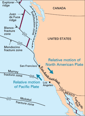 |
Major Pacific fracture zones, USGS
|
Think
of a ridge as a snaking slit-like window exposing ready-to-melt
asthenosphere to
the hydrosphere. Mafic asthenospheric melts well up along the axial valley of the ridge
to
freeze against the edges of twin slabs forming
on each side. In the map at right, the Pacific slab on the west is paired with much smaller twins across the
Explorer, Juan de Fuca and Gorda ridges. South of the Mendocino fracture
zone, the Farallon plate, a much
larger Pacific plate twin, has already subducted beneath California along with
the intervening ridge, the East Pacific Rise.
Submarine fissure volcanoes venting
pillow basalts dot the axial valley of the spreading center,
but down deep in the ridge, gabbro intrusions take over.
Together, the basalt and gabbro make up the igneous
basement of the oceanic crust. Ultramafic lithospheric mantle forms
simultaneously beneath the basement as chilled asthenosphere freezes to its
underside in a process known as underplating. Underplating progressively
thickens the slab's mantle layer, but the basement layer changes little during
the slab's time on the surface.
|
Magnetic stripe generation, USGS
|
As they form, the twin
slabs record the earth's current magnetic field as they move
away from the ridge and from each other in more of less symmetrical fashion.
They develop tell-tale magnetic stripes in the process. What drives the divergent plate motion across the ridge
is still not entirely clear, but gravity appears to be the prime mover
via a combination of hinge
rollback and ridge slide. Superheated brines
circulating through the fault-ridden ridge chemically alter the fresh slabs as they pass off
the ridge and onto the adjacent ocean floor. Basted basalt, anyone?
|
Ocean floor ages; red ~ 0-10 Ma, purple ~ 160-180 Ma
|
Once formed, the twin slabs go their separate
ways, eventually to meet
similar if not simultaneous fates in the most fundamental cycle in plate
tectonics. As they cool, they'll soon become denser than the
asthenosphere on which they rest, but they'll manage to stay topside for a while,
mostly via lateral compression by adjacent
lithosphere. Their residence times at the surface will be brief by continental
standards—only ~100 Ma on average. Ultimately, they'll sink into the
upper mantle from whence they came at separate and oppositely polarized subduction
zones that may or may not have existed at the time of their birth. After piling up and
dissolving back into the upper mantle along the "660",
their materials will reappear at the surface as new oceanic lithosphere generated at
some other ridge, usually one or more continents away from the ridge of origin.
Fracture Zones
The word "center" notwithstanding, spreading centers are linear, not radial,
seafloor
features. They are segmented and offset at varying intervals by perpendicular linear
seafloor
features known as fracture zones or transforms (which are not quite the same as transform
boundaries). Ultimately, fracture zones serve both to fit linear spreading center segments to
the earth's spherical surface, and to allow them to tap the
ripest asthenospheric magma sources available along strike.
|
Mendocino fracture zone
|
Although they do show some seismicity, fracture zones are neither fractures
nor continuously moving faults. Rather, they are welded sutures between slab
segments generated at adjacent offset ridge segments. Because fracture zones may
offset ridge segments by hundreds of kilometers, the slabs across them may
differ substantially in age and therefore also in depth. The Mendocino fracture
zone (right) separates seafloor segments differing in age by ~15 Ma, with scarps
over 1 km high across the fracture zone. In the map at right, the Mendocino
fracture zone offsets the Gorda ridge (off the coast of Oregon) from an adjacent
segment of the East Pacific Rise already subducted beneath California south of
the fracture zone.
Ocean Islands, Seamounts,
Submarine Plateaus and Aseismic Ridges
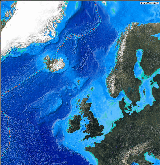 |
Iceland
|
Basaltic
ocean islands and
seamounts, in singles and in chains, and submarine plateaus dot the ocean floor all over the globe. They form atop
standard-issue oceanic
crust at particularly leaky spots along seafloor spreading centers,
at oceanic ridge-ridge-ridge triple
junctions, and also along extensional failures in the oceanic
lithosphere.
Some plateaus approach
subcontinental dimensions. Most plateaus remain submerged, but Iceland (right) is an intensely active emerging basaltic plateau straddling
an anomalous segment of the Mid-Atlantic Ridge.
Topographically, so-called aseismic ridges look much like mid-ocean
ridge segments, but they show no evidence of active ocean-floor spreading; hence
the name "aseismic". Two such ridges emanate from the Iceland plateau,
one connecting it to Greenland and the other underpinning the Faeroes. Aseismic
ridges are also likely to be extensional features. A particularly large aseismic
ridge is being consumed in the Nazca-South American subduction zone off Peru;
its buoyancy is likely the cause of the Nazca's shallow subduction angle beneath
Peru.
The
6,000 km long Hawaii-Emperor seamount chain (below) is probably built on a propagating
extensional flaw in the Pacific plate.
Hot Spots, Yes; Mantle Plumes, No
 |
Hawaii-Emperor seamount chain headed into the Aleutian trench
|
Oceanic islands, volcanic seamounts and basaltic submarine plateaus mark many
of the planet's hot spots—focused areas of excessive volcanism
like Iceland, Hawaii (right), Afar, the Galapagos, the Azores,
Yellowstone, the Snake River Plain, etc. Counts vary, but ~110 hot spots have
been recognized in the last 10 Ma, many of them still active. Most hot spots develop on or near plate
boundaries, but Hawaii and Yellowstone are notable midplate exceptions. One of the most prolific
hot spots ever known and certainly the most active today, the ^Hawaiian hot
spot (angled trace on the left in the map at right) has been punching up seamounts
in the center of the Pacific plate for at least 70 Ma.
Hot
spots probably have shallow roots in the upper mantle, but many are still commonly viewed as surface-penetrating melts induced by
narrow plumes of heat originating deep
within the lower
mantle. Plumes are said to move slowly if at all relative to the bulk earth and
are often invoked as a frame of reference for plate
motions.
Originally proposed in 1971 to explain the Hawaii-Emperor seamount chain and
the steady southward age progression of its lavas, the
mantle plume concept was soon applied to many other hot spots. Plumes have recently run afoul of
some well-established geophysical observations, however. For one thing, lower
mantle processes can't generate direct surface expressions with an impenetrable
barrier to material transfer in place at the upper-lower mantle boundary.
|
Northern Pacific floor with Hawaii-Emperor and many other volcanic chains
|
Then there's that pesky 60° angle between the south-trending Emperor chain and the
southeast-trending Hawaiian chain (right), both of which owe their existence to
the same long-running ^
Hawaiian hot spot. To explain the angle, plume models
require the Pacific plate, the planet's largest, to make a sudden 60° turn relative to
the "fixed" Hawaiian plume around 45±2 Ma, the age of the volcanic rocks
at the bend. That's a lot of mass to redirect, but the Indian subcontinent first
collided with the Eurasian plate about then, and a rapid global reorganization
of plate motions might well have ensued. In many well-studied parts of the
Pacific basin, ridge-generated patterns of seafloor magnetism should have
recorded such a direction change, but they show the Pacific plate holding a
steady course instead. This observation alone disproves the plume
explanation for the Hawaii-Emperor chain; more technical arguments disprove
plumes elsewhere.
Few of the many other volcanic chains adorning the Pacific floor show
anything resembling a steady age progression along strike, so the Hawaii-Emperor
is something of a fluke in that regard.
Hot Spots As Extensional Defects and Normal Upper
Mantle Temperature Variations
With the help
of radiogenic heating and the insulating effect of continental
lithosphere, heat escaping the lower mantle warms the upper mantle,
while subducted slabs, cratonic
keels, and mid-ocean ridges cool it. Since
self-organizing gravity-driven plate motions control the positions of the
continents, ridges and subduction zones, they also control the lateral temperature variations in the upper mantle.
These tectonic temperature fluctuations are more than sufficient to account for
all of the hot spots actually involving elevated surface heat flows. (Most are
no hotter overall than their surroundings.)
Several lines of geophysical evidence point to normal lateral temperature
variations of ±200°C in the asthenosphere and adjacent upper mantle around a
global mean of ~1,400°C. None of
the hot spots now recognized shows or requires a greater upper mantle
temperature spike than that, and most show asthenospheric temperatures well
under 100°C above the mean.
Most hot spots appear to be located by inter- and intraplate extensional stresses and driven by the
eagerness of the asthenosphere to break out wherever and whenever it can. If
the underlying asthenosphere is a bit hotter than usual, so much the better, but
thermal anomalies are the exception rather than the rule and are by no means
required.
Continental Lithosphere
Continental lithosphere is stiffer and thicker than oceanic
lithosphere—often 100-200 km thick and up to 250 km deep along cratonic
keels. Most of the planet's stock of old stable continental lithosphere was
created during the Archean Eon by earth
processes no longer active. Since then, new continental lithosphere has been created
primarily if not entirely along convergent plate
boundaries during subduction zone collisions, which have a tendency to convert to trapped oceanic lithosphere
and its arc-generated and ridge-generated
crustal embellishments into continental
lithosphere. (We owe much of Colorado's 1.7 Ga basement
to that process.)
 |
Alpine orogen
|
Continental lithosphere can't be consumed in large amounts
anywhere because it's far too buoyant to flush down a subduction
zone (try pushing a basketball underwater), but small quantities can be stuffed under the edge of another
continental plate—as at the Himalayas along the convergent Indian-Eurasian
plate boundary and
at the ^Alps
(right) along the convergent Adriatic-Eurasian plate boundary. Continental
lithosphere caught up in convergent plate boundaries
tends to compress, thicken, heat, metamorphose, fault and rise.
Continental Rifting
|
Afar triple junction
|
Once formed,
buoyant continental lithosphere strongly resists
recycling into the upper mantle, but continents as planetary surface features are by no
means permanent. Like political coalitions, continents are merely transient
assemblages of continental lithosphere, constantly rafting together, breaking
apart and regrouping—sometimes along similar lines, sometimes along vastly
different lines. All ocean basins ultimately result from successful continental
rifting. It is often the first step in the formation of sea
floor spreading centers, but rifts sometimes fail (die out) before an
ocean can form. Just as all slabs eventually subduct, all continents eventually
rift.
Afar
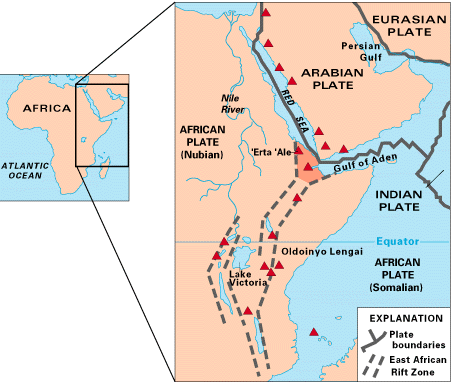 |
Afar rifts and volcanoes, USGS
|
Let's take a look now at two successful continental rifts
floored with oceanic crust. In
the maps above and at right, are the north northwest-trending Red Sea and the
northeast-trending Gulf of Aden. They meet the developing south-trending East African
Rift at a ridge-ridge-rift triple junction
and hot spot in the Afar region of Ethiopia and
Somalia. Whether the rift will eventually advance to the Red Sea stage, only time
will tell.
Note that the Afar region is a hot spot only in the
strict sense that excessive volcanism and seismic activity concentrate there.
There is no evidence of unusually hot mantle beneath Afar. Extensional failure
of the African plate is the root cause of all the commotion here, not a primary mantle distance.
Backarc Rifts
|
Sea of Japan and Sea of Okhotsk, backarc basins separating the
Japanese and Kuril Islands from the Asian mainland
|
A less dramatic but much more common form of rifting occurs in continental backarc
settings, where it goes by the name backarc spreading once ocean floor
appears. At most subduction zones, hinge
rollback requires overriding plates to extend to
maintain contact with the falling slab. Backarc rifting is the most common
response. Depending on how far they progress, backarc basins can accumulate
terrigenous rift, volcaniclastic and shelf-like marine sediments. When they
progress to seaways like the Sea of Japan, the arc can migrate away from the
mainland. When subduction zone collisions occur, as
they often do over the life of an arc, backarc basins often invert into complex
mountain masses composed of complex collisional crust
as the outboard arc is shoved back against the mainland. Repetitive
accordion-like backarc rifting and closing has long been important mechanism for
the generation of continental crust in mobile belts.
Recurring Rifts
Why
continents rift apart is a question under active geophysical and geologic
investigation, but regardless of the reason, large continents appear to be
inherently unstable over timescales of 100 Ma or so. Since all plates are weakest
in extension, this comes as no great surprise, but the nuts and bolts of the
process remain unclear.
An
oft-proposed mechanism for continental rifting with few compelling examples is
the build-up of lithosphere-weakening heat under large, thick continents acting as thermal blankets.
Since upper mantle beneath the interior of a
large continent can't cool itself by subduction or sea-floor
spreading, as it normally does, it could, if denied adequate circulation,
become hot enough over time to soften, elevate and eventually rift the overlying
plate. Lacking the refractory keels that
insulate the cratons, mobile belts
(like Colorado?) would be particularly susceptible, but the asthenosphere may
convect fast enough to prevent most if not all continent-splitting heat
build-ups. A growing body of evidence indicates that cold-start rifting related
to certain concentrated crustal loads occurs more often than hot failures of continental lithosphere.
|
San Andreas Fault System, Basin and Range and Rio Grande Rift
|
With the help of gravity, continents adjacent to mixed plate
boundaries that are partly divergent can also
literally fall apart. The western third of the Unites States has been doing just
that for ~30 Ma as the Pacific plate pulls away from North America there. This
particular mobile belt break-up is both distributed
over the entire Basin and Range and concentrated in the Rio Grande Rift of New Mexico,
Colorado and Wyoming.
Whatever the cause, the continents have been
rifting and regrouping in a supercontinent cycle since the onset of plate tectonics around ~2.0 Ga, with no end in sight.
Passive Continental Margins
|
Passive margins surrounding the Atlantic basin and Mid-Atlantic Ridge
|
Most plates include both oceanic and continental
lithosphere meeting along a solid and relatively quiet suture known as a passive
continental margin. Such margins always represent one side of a continental
rift that succeeded in opening an ocean basin. The Atlantic coasts of North
America, South America, Europe and Africa are major passive margins along the
sides of the same successful rift, now the Atlantic Ocean and still spreading
along the Mid-Atlantic Ridge (right). Over the lifetime of an ocean, passive margins like these can
accumulate very thick sedimentary piles eventually developing into broad
continental shelves resting for the most part on continental lithosphere
riddled with normal faults.
Basaltic volcanism and active normal faulting are the rule at developing
passive margins. The volcanism eventually ends as passive margins mature, but
the seismicity last much longer. As the growing continental shelves progressively load up the
fossil rift faults that gave birth to the adjacent ocean basin, upper crustal
adjustments in the form of passive margin earthquakes like the 1886 ~M7.3 Charleston, SC
event result.
Supercontinents
|
Pangea, complete and during break-up
|
Continents have been
clumping and splitting since the inception of plate tectonics at ~2.0 Ga. The
process has operated at all scales to produce supercontinents (unions of two or more
continents), microcontinents (slivers of continental lithosphere
produced in a variety of ways), and everything in between. Cratons,
the seemingly indestructible continental cores formed in Archean
time, have remained intact throughout but have recombined freely with other
cratons over time.
At the extreme, the planet has twice seen all of its continental lithosphere
gathered into a single landmass:
-
^Rodinia
began assembly around 900 Ma in the late Proterozoic and broke up
by ~600 Ma in the Cambrian
-
^Pangea
began assembly around 300 Ma in the late Paleozoic (not coincidentally at
the time of Colorado's Ancestral Rocky
Mountain orogeny), completed itself in the Late Permian (top right) and substantially sundered by
Late Jurassic (bottom right) time
There may have been
earlier single-continent episodes as well.
Lesser multi-continental rafts have formed with greater frequency. Gondwana
tied up today's southern continents from ~650 Ma to ~130 Ma. In between, it joined and left
Pangea. North America was trimmed out of Laurentia, a northern
supercontinent that once included Baltica (northern Europe) and the eastern part
of Gondwana. Today's largest continent, Eurasia, combines earlier continents
sutured at the Ural Mountains. India punched in at ~ 45 Ma, Africa has been
docking since ~80 Ma, and Australia is bearing down on it as we speak.
Why unsinkable continents collide
and bond temporarily is not hard to understand on a planet whose surface
dynamics are dominated by subduction. Why they rift
apart again is less clear, but upper mantle heat build-up related to the
insulating effect of continental lithosphere and isolation from the cooling
effect of subduction may play a role. Why the continents keep gathering into
large supercontinents is also a mystery, but the known frequency is higher than one would expect from
random plate motions alone—hence the concept of a supercontinent
cycle. Some theorize that supercontinents collect over large-scale mantle
downwellings, but we have no evidence that such downwellings have ever occurred.
Nor are the likely in an upper mantle constrained to circulate above the lower
mantle at 660 km.
Mixed Lithosphere
Lithosphere is usually either distinctly continental or decidedly oceanic,
and mostly the latter, but mixed situations occur now and then, usually in a rift
setting. For example, new oceanic
lithosphere developing at the bottom of an advanced continental rift
or backarc basin can
easily accumulate several kilometers of silica-rich sediments shed from adjacent
continental crust while the rift is still narrow. If the rift fails at that point, a sliver of
mixed lithosphere is left embedded within an otherwise continental plate. If the
rift goes on to form a world-class ocean basin, the continental shelves at its
margins will accumulate even thicker piles of continent-derived sediments
resting in part on oceanic lithosphere. If the rift is a backarc or ocean basin
that later closes in a collision, the lithosphere
formed there will be primarily continental in nature with a very complex
crust.
Top
Page Index
It's All About Subduction
|
Subduction zones ring the shrinking Pacific basin
|
Subduction
occurs when one plate slips under the edge of another at a convergent
plate boundary. The lithosphere on the
down-going side is almost always oceanic
because its negative buoyancy promotes subduction, but positively buoyant continental
lithosphere occasionally tries to go under as well, often with spectacular
results like the Alps or the Himalayas.
It has only recently been recognized that self-organized gravity-driven subduction, not mantle
convection, has been the mighty engine powering plate tectonics since
its inception at ~2.0 Ga. Furthermore, subduction largely drives the limited
convection found in the upper mantle, not the other way around.
And how does subduction rate the leading role? Ultimately, because heat loss
and gravity are the only important motive forces acting on the plates.
Continuing top-down cooling of the
upper mantle produces gravitationally unstable
oceanic lithosphere that progressively cools, thickens, stiffens, imbibes
water and becomes more dense through cooling and phase changes as it rafts away from its
spreading center
of origin. Not far from its spreading center, the oceanic lithosphere (slab
for short) is
already denser and stiffer than the hot asthenosphere on which it
rests. Flexural support and lateral
compression from surrounding slab segments may allow it to stay topside for a
while despite the density inversion, but eventually, all overdense slabs buckle
downward and sink subvertically into the upper mantle along a
convergent plate boundaries known as a subduction zones. Metamorphic
reactions occurring ~60 km below the surface make the crust of the falling
slab even denser, thereby speeding its fall.
The overdense subducting slab is the
prime mover in plate tectonics, and the prime upper mantle coolant as well.
Wooden Blocks
To understand how lateral compression can prevent an overdense slab from
sinking right away, think of some wooden blocks lined up on a table. If the line
isn't too long, you can squeeze its ends together and lift it off the table as a
unit, but the longer the line, the harder you'll have to squeeze. Add a little
weight to the center of the longest line you can lift intact, and it will
promptly collapse—i.e., the center will fall under gravity. To model the
contribution of flexural support, you could add
glue between the blocks, but with a long enough line, or enough added weight,
that would only delay the inevitable. If the glued joints proved stronger than
the wood, the blocks themselves would break to allow the collapse. Gravity will
not be denied.
Slabs behave in much the same way. Once they become dense enough with age,
they must fall. When they do, a subduction zone appears.
Subduction Zone Anatomy
|
Sumatra
|
Topographically, a subduction zone is marked by a
magmatic arc erupted
onto the overriding plate a variable distance behind a deep ocean trench.
Between the arc front and the trench is an accretionary wedge and a forearc
basin; the latter covers the true contact between the converging plates
while the former caulks it. The
forearc basin and the accretionary wedge together occupy the arc-trench gap.
At right is the Java
trench (deepest blue) off the Sumatra arc (the largest island shown). The
small islands lined up southwest of Sumatra mark the forearc ridge, the
divide between the forearc basin and the accretionary
wedge. The ridge breaks the ocean surface and the forearc basin is submerged
in this particular example, but other configurations are possible. Accretionary
wedges are almost always submerged.
 |
Sumatra arc cross-section, USGS
|
The cross-section through the Java trench and the Sumatra arc at right is
well-constrained by
geophysical data and is drawn without vertical exaggeration. The following features
are typical of real subduction zones but not of popular subduction diagrams
(which are often drawn inaccurately with very misleading vertical
exaggerations):
-
The trench, while quite deep, forms a very
shallow obtuse angle, usually 160-170°.
-
The actual contact between the converging plates is
beneath the forearc basin, not at the trench.
-
The falling part of the slab bends down (hinges)
well beneath the
overriding plate, not in front of it.
-
The forearc basin is rarely deformed by contact
between the converging plates because nearly all subduction zones are held
in tension, not in compression.
Now let's work our way from the slab and trench toward
the magmatic arc.
Slabs and Hinges
On average, oceanic plates are 80-90 km
thick when they finally begin to sink in earnest at a subduction zone. The
actively sinking portion of a subducting slab bends down into the asthenosphere
well
beneath, not in front of, the edge of the overriding
plate. The bend between the sinking and about-to-sink slab segments is
called the hinge.
Beyond the hinge, most slabs dip into the mantle at
30-70° angles, but important exceptions (like the low-angle Nazca plate
beneath the western margin of South America) occur.
Once the slab reaches a depth of ~60 km as it sinks past the hinge, the
basalt and gabbro making up its crust undergo phase changes to much denser eclogite,
a high-pressure metamorphic rock 200-250 kg/m3 denser than upper
mantle rock. The eclogite acts like a lead sinker, speeding the fall of the
slab. Water released into the mantle wedge overlying
the slab as a chemical byproduct of the eclogite transition eventually triggers
the partial melting that fuels arc
magmatism.
It's important to keep in mind that slabs don't really punch
into the mantle, as diagrams and popular animations often depict. Instead, the sinking segment
beyond the hinge falls broadside, like a paddle, toward the 660—the global upper-lower mantle
boundary at 660 km. Slabs do slide horizontally through the hinge region to
some extent, but their dominant
motion at and beyond the hinge is not a slide but a near-vertical drop.
Falling slabs often break up and may even fold up on the way down. Unable
to sink beyond the impenetrable 660, sunken slab fragments pile up there junkyard-like to
await recycling into
the upper mantle, eventually to reappear as melt at the spreading centers where new oceanic
lithosphere forms.
This fundamentally oceanic cycle has operated for the last ~2.0 Ga with no end
in sight. Indirectly, it also acts to redistribute the planet's fixed fund of continental
crust and its slowly growing fund of continental lithosphere.
Trenches and Accretionary Wedges
Over time, most trenches accumulate accretionary wedges—fault-riddled
jumbles of oceanic crust scraped off the falling slab mixed with sediments shed off the
overriding plate. (Think of the mass of dirt rolling before a bulldozer blade.)
Wedges usually rest on oceanic crust in front of the leading edge of the overriding
plate. Mature wedges keep the angle between the walls of the trench fairly
flat—usually in excess of 150°.
In most subduction zones, accretionary wedges effectively caulk, pad and lubricate the physical contact between slab and overriding plate.
In the process, they generate most of the world's earthquakes, including nearly
all of the ^very
largest. (The two largest shocks ever recorded, the ^May
27, 1964 M9.2 Alaskan earthquake in Prince William Sound and the ^May
22, 1960 M9.5 Chilean earthquake, are prime examples.) Only in the
sediment-starved trenches of small open-ocean arcs do the falling slab and the overriding
plate actually touch. Padding by the wedges probably contributes to the rarity
of forearc damage at subduction zones.
Forearcs
Between the trench and the arc, in the arc-trench gap, lies the forearc region. Basins filled
with volcaniclastic sediments often form atop the forearc; below and trenchward is the accretionary
wedge.
Interestingly, forearcs
rarely if ever show evidence of damage due to either compression or tectonic
erosion
along their contacts with falling slabs—apparently because most trenches are kept in tension
by hinge rollback. Even subduction zones with fast
convergence rates exceeding the rollback rate rarely show forearc damage. The
Nasca-South American boundary is such a subduction zone, and its forearc basins
remain undeformed even as the shallow-angle slab couples with and deforms the
Andes and the eastern foothills at and behind the Andean arc.
Mantle Wedges
Another important wedge at the subduction zone is the mantle wedge
situated between the top of the falling slab and the bottom
of the overriding plate. Low-viscosity asthenosphere
wells up into the mantle wedge as the slab falls away from the overriding plate.
The mantle wedge provides the melts that surface in the magmatic arc. In continental
arc settings, it also heats the backarc region via
conduction. If the backarc is actively rifting and thinning, the underlying
wedge can undergo partial decompression melting. These typically basaltic melts
further heat the backarc as they rise through it.
The Overriding Plate
|
Japanese Arc and the backarc Sea of Japan
|
Gravity-driven hinge rollback keeps most convergent
boundaries under tension, not compression; yet, gaps
between plates are never observed. At every subduction zone involving a falling slab,
the edge of the overriding plate somehow manages to hover unwaveringly over the bend in the
falling slab. Most overriding plates, oceanic and continental alike, extend as
needed to maintain contact with the free-falling slab, usually via backarc
or intra-arc spreading.
The forces driving this extension remain controversial, but they must be
irresistible, because they never seem to fail to maintain contact. Some authors
propose a viscous coupling that goes something like this: The falling slab draws
overlying asthenosphere toward it, into the mantle wedge.
The entrained asthenosphere in turn drags the edge of the overriding plate over
the slab hinge. Since it's easier to move the edge
than the entire overriding plate, and since plates are
weakest in extension, the edge pulls away until the forearc comes to rest
gently on the slab. Gravity acting on the overriding plate probably figures in
somewhere.
In the map above, backarc spreading in the Sea of
Japan and Sea of Okhotsk allows the Japanese and Kuril Islands to extend toward
and remain in contact with the subducting Pacific slab.
Subduction-related Shortening
| |
Nazca-South American subduction zone
|
Subduction-related compression of overriding plates is the exception rather
than the norm. Prior to 29 Ma, California, a typical case in this regard, hosted a subduction
zone continuously active for over 100 Ma with no significant forearc
shortening. If compression had ever developed across this long-lived subduction
zone at the point of initial plate-to-plate contact, the forearc would have been
the first structure to deform.
Overriding plates crumple due to subduction only under one or more of the
following uncommon circumstances:
In many such cases, the subducting slab ends up
falling at a shallow enough
angle to couple mechanically with the overriding plate well beyond the
trench. Often, overriding plate compression involves a combination of these
factors. The North American Laramide
Orogeny probably involved a combination of the last two.
When continental overriding plates compress,
closure of their backarc basins creates hot orogens
that generate complex new continental crust.
Magmatic Arcs
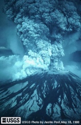 |
Mt. St. Helens, 1980
|
Active subduction zones involving a falling slab also include a magmatic
arc, a band of intense volcanic and intrusive activity affecting the
overriding plate. When the top of the falling slab reaches a
depth of 80-120 km, partial melting begins to occur in the barely
solid hot mantle wedge just above the slab. These
first melts rise to the surface along the arc's volcanic front. In
general, the greater the dip of the falling slab, the sooner the slab reaches
the first-melt depth contour, and the narrower the arc-trench gap. Melts
and mantle heat also rise along a band of varying with behind the volcanic front
known as the backarc. Extension and rifting of the
backarc work to accommodate hinge rollback.
Where Do the Melts Originate?
Exactly how arc melts develop in the mantle wedge
remains controversial, but everyone agrees now that they don't involve melting
of the subducting slab itself. One promising recent
proposal involves serpentinite as a important intermediary. As slabs fall,
they release large amounts of water from entrained sediments and also as a
byproduct of the metamorphosis of their basalt
and gabbro to eclogite
at ~60 km.
The rising water reacts with peridotite in the immediately adjacent mantle wedge
to form a layer of serpentinite that rides along the top of the slab. As long as
it remains stable, the serpentinite effectively
shields the mantle wedge above by absorbing the watery fluids rising from the slab. But when
it reaches a temperature of 600-650°C, usually at a depth of 80-120 km, the
serpentinite decomposes and releases its water into the overlying mantle wedge.
At these depths, these secondary watery fluids induce partial melting of the
adjacent mantle wedge by reacting with anhydrous mantle
minerals to form hydrated minerals with melting points below the ambient mantle
temperature. The resulting partial melts rise toward the surface through the
mantle wedge and the overriding plate to form the magmatic arc.
Arc Variations
Bear in mind
that the arc is not a fixed feature of the overriding plate. Rather, its
location tracks the depth of the subducting slab beneath it like a gigantic contour
line drawn with volcanoes.
Since the slab begins to generate ^magma
(melt) only when its top lies 100±20 km below the surface (i.e., when its
serpentinite crust decomposes at 600-650°C), the location of the volcanic front
relative to the trench
changes as the dip of the falling slab varies. As the dip of the Farallon
plate subducting along the West Coast shallowed out progressively during the Laramide
Orogeny, associated arc magmatism migrated
rapidly to the east from the Sierra Nevada, its original locus, to the Rockies.
When the entire slab rose above the melt-generating depth, arc magmatism snuffed
out.
Since deeper slab segments also induce asthenospheric melts, arc magmatism
affects a band of variable width behind the volcanic front. In general, the greater the dip of the falling slab, the sooner the slab reaches
the first-melt contour, the narrower the arc-trench gap and the narrower
the magmatic arc behind the front.
Active volcanism is a common feature of magmatic arcs, as anyone from Oregon, Mexico,
Chile, Japan, Fiji, Indonesia or the Philippines will
tell you, but subsurface intrusions are also important in arc
evolution. At right above is Mount St. Helens, part of the Southern Cascades arc.
Below it is a magma chamber that may well freeze in place one day to become an
intrusive component of the arc.
 |
Augustine Volcano
|
At any given point along an evolving subduction zone, the overriding plate
may be continental, oceanic
or something in between, as at ^Augustine
Volcano (right), an active vent in the eastern Aleutian Archipelago fed by
melts generated by subduction of the Pacific plate beneath the Alaskan portion
of North America. Each overriding margin type responds to
subduction in its own way, but in every case, a magmatic arc eventually
forms a variable distance back from the trench.
Magmatic Evolution
|
Tectonic setting of the Southern Cascade arc, USGS
|
Arc magmas
tend to be basaltic at young oceanic arcs, andesitic at mature arcs and
rhyolitic or dacitic at continental arcs. The
initially basalt-like
mafic melts feeding magmatic arcs come not from the sinking slab, as popular
diagrams commonly show, but from a complex hydration
process in the mantle wedge above it (the red
zone at far bottom right in the diagram at right). As the proto-magmas rise from their
mantle source region, they interact with
surrounding mantle and crustal materials in a number of ways, including:
-
Fractionation by partial freezing that
pulls high-temperature minerals out of the melt sooner than others.
-
Assimilation of wall rock along their
conduits, with or without water exchange.
By
the time they reach the surface, some asthenospheric melts are still quite
basaltic, particularly at small, primitive open-ocean island arcs, but they may also
become quite felsic in more mature oceanic and continental arcs. Arcs that start
out spewing primitive runny mafic basalt
and end with explosive eruptions of sticky, highly felsic rhyolite
are said to be bimodal, and they're fairly common. However, the average
arc lava, andesite,
falls somewhere in between, both in composition and viscosity. Dacite is another
common felsic product intermediate in silica content between andesite and
rhyolite. Viscous andesitic, dacitic and rhyolitic magmas charged with ^gas
tend explode on reaching their vents, especially the high-silica dacites and rhyolites.
Low-silica basaltic magmas tend to erupt much more peacefully, as on the island of Hawaii.
 |
Mount Pinatubo, 1991
|
At
right is ^Mt.
Pinatubo, a notorious Philippines island arc stratovolcano with
predominantly andesitic and dacitic output located on the island of Luzon.
Glowing cloud eruptions and volcanic mudflows (lahars) ravaged Luzon and
killed thousands during Pinatubo's vicious June, 1991 eruption sequence. The June 12,
1991 explosion shown here sent up a towering vertical (Plinian) ash
column and injected heavy loads of sulfur dioxide into the stratosphere. In the
culminating cataclysmic eruption of June 15, 1991, Pinatubo lost 500' of its
5,275' pre-eruption height.
Continental arcs
|
Andean orogen
|
Subduction-related magmatic arcs built on overriding
continental plates tend to erupt explosive rhyodacitic magmas. Modern examples include the
the Andes of Chile and Peru (right), the Southern
Cascades of Washington and Oregon (shown in cross-section in the diagram
above) and the Apennines of Italy.
The Andes arc remains fully active as the Nazca plate flooring the SE Pacific basin
subducts rapidly beneath the west coast of South America. The active Cascades
arc draws fire from the small Juan de Fuca plate still subducting along the
Washington and Oregon coasts. The Sierra Nevada mountains of California are the uplifted and eroded fossil
roots of a now abandoned continental arc active off and on at ~145-30 Ma, when
the Farallon plate of the Pacific basin subducted under the west coast of
California.
|
Mt. St. Helens, 1980
|
As they evolve, continental arcs absorb and erupt subduction-induced magmas
of increasingly felsic compositions (high in silicon and aluminum and low in
iron and magnesium) as the rising magmas entrain more
and more sialic (silicon- and aluminum-rich) material during their passage through lower
continental
crustal levels. The higher silica concentrations lead to more explosive
eruptions, as at Mt. St. Helens on May 18, 1980 (right). Accretionary wedges along continental arcs are typically
large due to generous sediment influxes from a large and typically mountainous eroding
coastal landmass.
|
Japanese Arc and the backarc Sea of Japan
|
Continental margins at subduction zones extend toward the trench to
keep up with hinge rollback. This extension is
usually localized to the backarc, the heat-softened magmatic belt just behind
(inland of) the volcanic front. The backarc is doubly heated—from below by mantle
wedge circulation and from within by magmatism that strays behind the
volcanic front. As extension progresses, rifting will
appear within either the arc or the backarc to form a backarc basin. As
they develop, continental backarc basins accumulate varying volumes of terrigenous rift, volcaniclastic
and even shelf-like sediments, depending on the
setting. If a subduction zone collision doesn't close
the basin first, the basin will eventually become a seaway that pushes the arc
front away from the mainland via seafloor spreading, as the Ryuku, Japanese and
Kuril arcs have
done at right.
Oceanic (Island) Arcs and Backarcs
 |
Sunda arc
|
Subduction-related oceanic
or island arcs built on overriding
oceanic plates tend to erupt basaltic to andesitic magmas, depending on their
maturity. Modern examples include the Tonga-Kermandec
Islands east of Australia, the Philippines, and the ^Lesser
Sunda Islands (right, Timor is the largest) of Eastern Indonesia north of
Australia.
Island arc volcanic and intrusive igneous rocks tend to be more mafic than
those of continental arcs because their magmas pass though more mafic lower
crust on their way up. Island arcs are more flexible than continental arcs
and can more easily reshape themselves as conditions along their subduction zones change. Accretionary
wedges along island arcs are usually smaller than their continental
counterparts.
Open-ocean island arcs also undergo backarc spreading to accommodate hinge
rollback, but they accumulate sediments . Many of the curious double arcs of the
western Pacific basin have been split by backarc spreading.
Composite Arcs
|
Sumatra
|
Any oceanic arc over 64 km (40 mi) wide is likely to be a composite of
several arcs sutured together in the wake of one or more arc-arc
collisions. In the process, composite arcs tend to develop significant
amounts of continental crust. Notable examples include
Sumatra (right), New Zealand's south island and the Philippines and the Japanese
islands.
Hinge Rollback
|
Juan de Fuca slab falling beneath the Southern Cascade arc, USGS
|
Slab fall is by far the dominant drive for plate tectonics, but it can play out on the surface in
surprisingly complex ways, particularly due to a phenomenon known as hinge
rollback. The diagram at right would be more accurate if it showed the slab
beyond the hinge falling faster than it dips into the mantle and the hinge
steadily moving back toward the trench.
As the dipping edge of a foundering slab falls toward the "660",
its hinge rolls back (retreats) into the segment still topside and draws
the overriding plate over its hinge in the process. The overriding plate
stretches or moves toward the retreating hinge, as its situation and material properties allow, in order to maintain contact with the subducting slab.
(Gravity, lower crust ductility in the overriding plate and asthenospheric
mobility would all work to fill any gap that might otherwise develop at the trench.)
This well-documented hinge-chasing behavior of overriding plates is a
critical element in the latest formulation of plate tectonics.
It plays a crucial
role in driving plate motions and in the development of ocean basins and continents alike.
Ridge Slide
A second minor way in which a slab might fall subhorizontally is called ridge
slide. As a slab moves away from its ridge and cools from the top, the lithospheric mantle along its
underside thickens by ~100 km due to underplating by cooling asthenosphere. The viscous boundary between the
slab and the underlying asthenosphere thus forms a shallow ramp sloping down
from ridge to subduction zone. Slabs might theoretically slide down this ramp
under gravity, but direct evidence of ridge slide is lacking.
Contrary to popular accounts, there is little if any "ridge push" at spreading
centers (the nascent oceanic lithosphere there is too thin, hot and floppy to
push anything around), and little if any "slab pull", since the foundering slabs
sink subvertically rather than slide sideways into the upper mantle and probably
lack the required tensile strength to drag along distant topside segments anyway. Nor is there credible
evidence that upper mantle convection currents push cratons around by their
keels like so many upside-down sailboats.
Hinge rollback and ridge slide motivate the plates to move around the surface of the
planet—not mantle convection, slab push or slab pull.
Hinge Rollback at Oceanic
and Continental Arcs
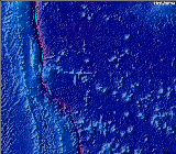 |
Seamount chain subducting at the notch in the Izu-Mariana trench
|
Much of the malleability displayed by subduction zones over time is accomplished by
backarc spreading modulated by along-arc variations in hinge rollback.
If the arrival of a buoyant ocean floor edifice temporarily slows or halts hinge
rollback and overriding plate extension at one point along a long subduction
zone, hinge rollback will "festoon" (Warren Hamiliton's nicely visual
word) around the tack point, while the overriding plate extends around the
compressive section to follow the altered hinge geometry.
Iwo Jima and the Volcano Islands stand above a notch (tack point) in the long,
continuous Izu-Mariana trench east of Japan (above). The largest remaining seamount
in an east-west chain now subducts at the notch. South of the notch, backarc
spreading widely splits the Mariana arc (right) to keep pace with unfettered
hinge rollback away from the notch. The Bonin arc north of the notch has split
as well. Both splits pinch out at the notch (right), which first and foremost
marks the local absence of rollback and extension.
|
Japanese Arc and the backarc Sea of Japan
|
Rollback engenders similar splits along continental arcs. The Yellow Sea, the
Sea of Japan and the
Sea of Okhotsk all occupy well-developed backarc basins developed along the west coast of
mainland Asia behind the Ryuku, Japanese and Kuril arcs, respectively. The
Yellow Sea's large continental shelf collects
mature sediments from several major rivers draining much of China. Such
sediments would not be found in the backarc basin of an island arc.
A more diffuse style of continental backarc extension caused the
initial (but not current) stage of normal faulting in the Basin and Range of
the western United States between 40 and 29 Ma—after post-Laramide resumption of
normal-angle subduction and hinge rollback along the West Coast, but before
subduction of the East Pacific Rise and the cutting of the San
Andreas fault.
|
Andean orogen
|
Finally, note the prominent notch in the west coast of South America and the
highest segment of the Andes surrounding it. One theory for the notch posits
that asthenospheric drag on the continental keel pulls the entire midsection of
the South America to the east relative to the rest of the continent, notch
included. I wonder about the two aseismic ridges entering the trench at the the
notch. Much of the Nazca-South American subduction zone around the notch is
currently in compression due shallow slab subduction, which is in turn due to a
combination of faster than usual plate convergence and the subduction of buoyant
ocean floor edifices like the Nazca Ridge off Peru. Could extension of other
segments of the west coast have played a role in shaping the notch, perhaps in
the past? I hope to research this question.
Top
Page Index
Subduction Zone Collisions
|
Costa Rican arc
|
Even a casual glance at a shaded relief map of any ocean basin sans water
will convince you that the oceanic crust is far from smooth, even over the
abyssal plains that make up the bulk of the world's ocean floor. In fact, the
ocean basins have more relief on average than the continents. As the map
of the Costa Rican segment of the Middle America Trench at right shows, the ocean floor
bristles with
-
long, high sinuous mid-ocean
ridges, like the Cocos ridge at bottom right
-
island arcs and trenches, large and
small, like Costa Rica
-
seamounts, singly and in large
chains—among them the world's largest and tallest mountain, Mauna Loa, and the Fisher Seamount chain off Costa Rica's central coast
-
vast submarine basaltic
plateaus, like the Quepos Plateau entering the trench south of the Fisher
Seamounts
-
fault scarps, some
over 1 km tall
-
seemingly random bumps and swells that as yet have no clear
explanation.
The larger bumps don't always go down easily at subduction
zones,
particularly if they contain a lot of buoyant arc-generated
or continental crust. When a sufficiently large or buoyant incoming continental fragment or oceanic edifice
(like an arc or a submarine plateau) jams into a subduction zone,
compressive stresses wrack the overriding plate, often with sufficient
force to close and even invert any backarc or intra-arc basins that may have
formed due to earlier hinge rollback.
Open-ocean island arcs often
wrap themselves around such obstructions via variations in hinge
rollback, but continental
arcs are more inclined to shorten along collision zones. Through tectonic
burial, temperature- and pressure-related recrystallization and compressive
uplift, the jamming edifice, surrounding trench fill, nearby arc materials and
any associated inverted backarc basins often end up as elevated metamorphic crust after
the collision, no matter how deep they may have been dragged in the throes of
the collision.
Buoyant but less obstructive slab features may instead flatten the angle of
subduction beneath the overriding plate. In such cases, the flattened slab often
couples mechanically with the overriding plate well inboard of the trench.
Rough Going in Costa Rica
|
Costa Rican arc
|
The map at right shows typical seafloor topographic
variation along the southern Middle America Trench, where the Cocos and Nazca
plates subduct beneath the Costa Rican magmatic arc built on
the oceanic southwest margin of the Caribbean plate. At the top of the map, the
subducting Cocos slab off Nicaragua is fairly smooth down to Costa Rica's Nicoya
Peninsula (the largest of the horsehead-shaped salients). Further south, the
Cocos plate bears many seamounts and submarine plateaus.
Their buoyancy flattens the dip of the subducting slab beneath central Costa
Rica, where the magmatic arc bows northeast away from the trench as it follows
the 100 km depth contour of the falling slab. Further south, the thick crust of
the Cocos Ridge enters the trench. The subducting seamounts also appear to
control the location and style of Costa Rica's many large subduction
zone earthquakes.
Arc-Related Collisions
Arcs are less buoyant than continents but are still too light to subduct
without a fight. Triassic through Jurassic arc-continent collisions along the
west coast of the US deformed the overriding North American plate several
times—among them the Antler, Sonoma and Nevadan Orogenies. These events were
not felt not as far east as Colorado, but they added a good bit of land and
rumple through at least California and Nevada. Some of the added terranes were
later carted away to the north along major transform
faults to take up residence in southwest Alaska.
Continent-Continent Collisions
|
Himalayan orogen
|
When two continents collide along a
subduction zone, the underthrusting
continent goes down only so far, and world-class mountain ranges come up.
Colliding
continental sections of the Indian and
Eurasian plates have been pushing up the Himalayas and the Tibetan Plateau
(right) over the subducting Indian plate since 45 Ma. Most arc-related
collisions are mere fender-benders by comparison.
|
Alpine orogen
|
|
Anti-Atlas orogen
|
The
ongoing collision of the Eurasian and African plates began ~80 Ma ago. On the
west, it's managed to fold up the Atlas and ^Anti-Atlas
Mountains of Morocco (left) on the down-going African side. Further east,
it's thrown up the Alps (right) on the overriding Eurasian side of the collision zone.
Caught Between a Rock and a Hard Place
Oceanic edifices trapped in the closing
ocean or sea between colliding continents often
end up in the mix of elevated crust at the suture zone. The intervening swarm of oceanic arcs
and small continental fragments in and around the ^Banda
Sea of Eastern Indonesia (right) will make for some very complex collision-generated
continental crust when northbound Australia and Southeast Asia
finally meet.
The Supercontinent Cycle
|
Atlantic Ocean, v. 3
|
J. Tuzo Wilson, one of the fathers of modern plate tectonics, recognized
early on that ocean basins often open and close repeatedly along similar but not identical passive continental margins, presumably
along bands of enduring
lithospheric weakness. An oft-cited example of the Wilson cycle is the rifting
of the supercontinent Pangea to form the current Atlantic basin subparallel to Appalachian and
pre-Appalachian orogenic belts left by earlier closings of the Iapetus and Rheic
Oceans in latest Proterozoic through late Paleozoic times. This accordion-style
"split and come back together" continental regrouping is termed introversion.
On the regrouping side, introversion makes sense to the extent that supercontinents
collect over
large-scale mantle downwellings that persist throughout their breakup, but then the
breakups themselves become hard to explain.
Recently, the Wilson cycle has been expanded to a "supercontinent
cycle" that also includes cases where supercontinents split and reorganize
by closing external oceans rather than by reclosing internal oceans. This "split and stick to the walls"
pattern is termed extroversion. The
breakup of the supercontinent Rodinia ca. 1.1-0.6 Ga and the subsequent
formation of Gondwana ca. 0.6-0.55 Ga appear to have involved just such an
extroversion through the closing of portions of a large peri-Rodina ocean. One
theory of extroversion has continental fragments sliding off a thermal (and
physical) high developing in the mantle beneath the dispersing supercontinent.
The fragments
reconvene over a large-scale mantle downwellings marked by subduction zones.
However, this explanation becomes difficult if subduction is purely
gravity-driven and upper and lower mantle motions are decoupled, as this article
favors.
As usual in earth science, the introversion and extroversion models are simply
end
members in a spectrum of possible supercontinent behaviors. Like it or not,
mixed cases are probably the rule rather than the exception. For example, the
formation of the Appalachian orogen turns out to be more complex than the simple
Wilson cycle would suggest, as it now appears that the passive margin that
separated from Laurentia (the main North American precursor) to open the Iapetus
ocean was not the margin that later collided with Laurentia when Iapetus closed.
Growing and Shrinking Oceans
|
Ocean floor ages; red ~ 0-10 Ma, purple ~ 160-180 Ma
|
For the continents to clump and split, some oceans must grow while others
shrink. The modern Atlantic is a growing ocean with one very small subduction
zone at the Lesser Antilles. Elsewhere, its large twin slabs
end against passive margins and transforms
with no other consumption to offset spreading at the Mid-Atlantic and peri-Antarctic
ridges. Larger Atlantic
subduction zones will develop when its slabs are ready to fall in earnest, but
for now, the slabs are managing to stay topside.
The Atlantic grows largely at the expense of the Pacific, a much larger but
shrinking ocean that continues to lose area to hinge
rollback at its many major subduction zones even
though its ridges post some of the fastest spreading rates on earth. As North
America passes over upper mantle once beneath the Pacific, material recycled
from long-gone Pacific slabs reappears in new Atlantic slab segments.
If the Pacific eventually closes this time around, we'll be able to say that
Pangea ended in extroversion like Rodinia before it. If the Atlantic closes
instead, we'll have a 3rd introversion
The Continental Crust Shuffle
A less obvious consequence of the supercontinent cycle is a global traffic in
continental crust. Whether though the closure of internal or external oceans, the continued
formation and subsequent breakup of supercontinents allows continents to exchange parcels of crust
at their margins. The result is a slow, sliver by sliver redistribution of continental crust over the
globe. Take the margins of the Atlantic basin (above right), currently is in its 3rd edition. Along the way, North America
acquired pieces of Africa and South America, while Scotland and Norway came away with
pieces of North America. For a stage-by-stage
walk-through of the process, drop by Lynn Fichter's ^Wilson
cycle tutorial.
Continental Evolution Through Subduction
Most of the globe's endowment of true high-silica continental crust seems to
have formed in the Archean Eon through
obscure earth processes
never repeated since, but the continents continue to grow along their margins
via
subduction, which effectively rafts in or welds on more primitive (mafic) crust developed in
the volcanic arcs and backarc basins surrounding
subduction
zones and in the large submarine basaltic plateaus and aseismic ridges erupted over oceanic ridge-ridge-ridge
triple junctions and other leaky ridge segments. As subduction plays out in the ocean basins,
continents are endlessly reorganized
through rifting and collisions, through large-scale strike-slip faulting (as
along the San Andreas and Queen Charlotte faults of the western North American
margin), and through accretion of oceanic elements.
On ocean closure, ocean floor edifices too buoyant to subduct are swept up
into the crust along the suture between approaching continents. When the
continents next rift apart along roughly the same suture (as they sometimes do), this material, now metamorphic, will have been
incorporated into one or both of the new passive continental
margins. The supercontinent cycle ensures that at least some older continental materials also
change hands as continents part and regroup through time.
Top
Page Index
Intraplate Deformations
 |
The Laramide orogen
today, now split north-south by the Rio Grande rift.
|
Plate tectonics is a
well-developed discipline only in the vicinity of plate margins and has only
been operative, as best we can tell, for the last ~2.0 Ga. Geoscientists still
struggle to understand the strong and repeated intracontinental
deformations so beautifully wrought in Colorado and surrounding states (right).
As noted above, fully 15% of the
earth's surface currently violates the basic plate tectonic model of rigid
plates interacting and deforming only at their boundaries. Far-field
plate tectonic stresses, gravitational collapse
and mantle stirrings all appear to be involved in intraplate deformations.
Far-Field Stresses: Southern Asia and Colorado
Far-field stresses generated at distant plate
margins can produce significant intraplate deformations, especially when they
can exploit local weaknesses. The exact mechanisms remain under debate, but mobile
belts, with their thinned lithosphere and many lithosphere-scale faults, are
particularly susceptible to far-field deformation.
|
Tibetan Plateau
|
Modern Asia's topographic response to the ongoing Indian-Eurasion continent-continent
collision is easily recognizable over a 2,000 km-wide swath roughly centered
on the Tibetan
Plateau (left). North of the plateau, hundreds of kilometers beyond the plate
boundary near the Himalayan front, is a far-field fold and thrust belt itself
hundreds of kilometers wide. And well beyond that to the northwest are western
China's Tian Shan mountains, the product of complex a far-field strike-slip
regime involved in Southeast Asia's eastward flight from the Indian-Eurasian
collision path. To the east of the Tibetan Plateau, swarms of north-trending
far-field strike-slip faults extending far into Southeast Asia accommodate
India's penetration of the Eurasian plate.
A similar scenario may have developed in western North America around 300 Ma,
when deeply intracontinental Ancestral Rocky Mountains
(ARM) rose in Colorado in response to the Ouachita Orogeny, a
continent-continent collision between North America and Africa that played out
nearly 1,000 km to the southeast during the final assembly of the supercontinent
Pangea. The particular basement-involved deformation style
seen in the Ancestral Rocky Mountains
lacks a good Himalayan analog, but the far-field tectonic settings are somewhat
similar.
|
Andean orogen
|
Colorado's next major far-field event, the Laramide
Orogeny at ~72 to 40 Ma, is harder to explain. Most current investigators
attribute the Laramide to east northeast-trending regional crustal shortening
related to an episode of flat or very shallow-angle subduction beneath the
western margin of North America, then some 800 km away. The Laramide ended with
a devastating mid-Tertiary magmatic bang
as the now departed Farallon Plate
finally fell away from the underside of the continent to re-expose the
lithosphere of the western US to an inflow of hot asthenosphere.
A similar shallow-angle subduction scenario appears to be unfolding (or more
accurately, folding) in the eastern Andes today in response to balky subduction
of the Nazca Ridge (that large southwest-trending linear sea floor feature off
southern Peru in the map at right) at the western margin of South America. The
basement-involved style of deformation is a good match for the Laramide's, but
this modern analog isn't as far afield. In any event, how the required forces
are transmitted from the shallow slab to the shortened inboard crust remains a
matter of much debate.
In order to produce major deformations the likes of the Ancestral Rocky Mountains
and the Laramide Rockies at distances of 800 to 1,000 km, plate-generated
far-field stresses usually have to reactivate (capitalize on) pre-existing crustal and lithospheric
weaknesses. In Colorado, basement-penetrating Late
Proterozoic rift faults and much older lithosphere-scale Early
Proterozoic fossil sutures provide many such opportunities, and the rock
record indeed confirms repeated activity on some, like the Gore fault along the
west flank of the Gore Range. This Early Proterozoic discontinuity was clearly
reactivated during both the ARM and the Laramide orogenies.
Since ~28 Ma, far-field extension and regional uplift have dominated the
tectonic regime in Colorado — particularly along the Rio
Grande rift. The Pacific plate's westward divergence relative to North
America no doubt facilitates the extension in concert with gravitational
collapse, but the large-scale domal uplift accompanying the extension is
difficult to envision as a primary or even secondary far-field plate effect. Nor
is it entirely explainable as the shoulder uplift that normally attends
continental rifting. Mantle forces unrelated to
plate tectonics may also be at work here.
Gravitational Collapse
|
Basin and Range
|
A pile of sugar heaped beyond its sustainable angle of repose (~30°)
slumps until its flanks are once again capable of self-support. Thanks to the
lithosphere's very limited tensile strength,
uplands lifted beyond their limits of internal support do much the same.
Oversteepened regions like the Himalayan front (at bottom in the image above) and the Basin and Range of the
western United States (left of center in the image at right) eventually fail and spread out under their own weight in a common
process known as gravitational collapse. The Southern Rockies appear
to be doing the same along the Rio Grande rift.
Normal faults rooted in
low-angle detachment surfaces accommodate gravitational collapse at brittle upper crustal
levels, while the underlying ductile lower crust
slowly flows downhill. The Basin and Range province has extended in this manner by more than 100%
in response to an over-steepening of Rockies and the Pacific plate's slow
westward pull-away from North America along the San Andreas transform.
East of the Colorado Plateau, the extension has topped 300%, in part to
accommodate a ball bearing-like clockwise rotation of California's Transverse
Ranges along the San Andreas fault.
Gravitational collapse may also operate at subduction zones,
where overriding plate margins seem quite willing to stretch
as needed via intra-arc or back-arc spreading to maintain
contact with the falling oceanic slab.
Mantle Contributions
As ever more sophisticated remote sensing technologies begin to unmask the stirrings of the earth below the
lithosphere, it becomes increasingly likely that upper mantle processes ostensibly unrelated to plate interactions
can also shape intraplate regions. In Colorado's case, the greatest lithospheric
deformations
follow the Rio Grande Rift and the
Colorado
Mineral Belt, the state's most profound structural defects. Upwelling of the
upper mantle appears, at least in part, to drive the large-scale domal uplift and rifting centered at the
intersection of these two lineaments near Leadville. Along the southwest
flank of the dome, unusually numerous travertine springs dotting the floor of
the Grand Canyon outgas anomalously high quantities of CO2 and 3He.
The latter, a primordial isotope no longer produced anywhere in the solar system
outside the center of the sun, can only come from the mantle. Why the upwelling
occurs just here, and not elsewhere in North America's great western mobile
belt, is anybody's guess.
Top
Page Index
References
In addition to the home page references, this
article relies on the sources cited below
and in the Colorado
Geology Overview article. I'm particularly indebted to Warren Hamilton of the
Colorado School of Mines Department of Geophysics for revamping my understanding of plate tectonics
through his articles and personal communications.
-
Anderson DL, 2002,
How many plates?, Geology v. 30, p. 411-414 (May)
-
Anderson DL, 2001,
Top-Down Tectonics?, Science v. 293, p. 2016-2018
-
Anderson DL, 2000, Thermal
State of the Upper Mantle; No Role for Mantle Plumes, online pre-print
submitted in revised form to Geophysical Research Letters, May, 2000
-
Bilek SL, Schwartz SY,
DeShon HR, 2003, Control of seafloor roughness on earthquake rupture
behavior, Geology v. 31, p. 455-458 (May)
-
Bokelmann GHR, 2002, Which forces drive North
America?, Geology v. 30, p. 1027-1030 (November)
-
Collins WJ, 2002, Hot
orogens, tectonic switching, and creation of continental crust, Geology v. 30, p.
535-538 (June)
-
Favela J and
Anderson DL, 1999, Extensional
Tectonics and Global Volcanism, online pre-print submitted for book
publication to Erice, Italy Conference Proceedings, November, 1999
-
Hamilton WB, 2003,
An Alternative Earth, GSA Today, v. 13, p. 4-12 (November); now
available in ^PDF
-
Hamilton WB, 2002,
"The Closed Upper-Mantle Circulation of Plate Tectonics", in Stein
S and Freymueller J, eds., Plate boundary zones, AGU Geodynamics
Series, v. 30, p. 359-410.
-
Hamilton WB, 1995,
"Subduction systems and magmatism", in Smellic JL, ed., Volcanism
Associated with Extension at Consuming Plate Margins, Geological Society of America
Special Publication No. 81, p. 3-28.
-
Hattori KH and
Guillot S, 2003, Volcanic fronts form as a consequence of serpentinite
dehydration in the forearc mantle wedge, Geology
v. 31, p. 525-528 (June)
-
Jackson J, 2002,
Strength of the continental lithosphere: Time to abandon the jelly
sandwich?, GSA Today v. 12, no. 9, p. 4-9 (September)
-
Marshall JS, Idelman
BD, et al., 2003, Landscape evolution within a retreating volcanic arc,
Costa Rica, Central America, Geology v. 31, p. 419-422 (May)
-
McCaffrey R, Abers GA, 1991, Orogeny in
arc-continent collision: The Banda arc and western New Guinea, Geology
v. 19, p. 563-566 (June)
-
Murphy JB, Nance RD, 2003,
Do supercontinents introvert or extrovert?: Sm-Nd isotope evidence, Geology v. 31, p.
873-876 (October)
-
Rogers, RD, Hrafnkell K and van del Hilst RD,
2002, Epeirogenic uplift above a detached slab in northern Central America, Geology
v. 30, p. 1031-1034 (November)
-
Small C, Danyushevsky
LV, 2003, Plate-kinematic explanation for mid-ocean-ridge depth
discontinuities, Geology v. 31, p. 399-402 (May)
-
Vorlink MW, ^Tectonics
of the Banda Arc website.
-
www.mantleplumes.org
— this often irreverent site dedicated to the eradication of mantle
plumes in geodynamics offers many links and online articles to support
its compelling case. Entrenched scientific fantasies die hard, however wrong
they may be.
Top
Page Index
URL: http://www.cliffshade.com/colorado/tectonics.htm
|